Wednesday, 11 May 2022

Red Hill ZL3/CB-411 May 2022

 The run of fine, settled Autumn weather in Canterbury continues! Red Hill was the target summit this week, located in one of our favourite SOTA playgrounds - Korowai/Torlesse Tussocklands Conservation area near Porters Pass. We have noted a marked increase in calls from Australia when we alert and spot on SOTA summits that are also located within WWFF.co designated parks/conservation areas. The excellent Parks n Peaks website has a variety of tools and information. Give it a try and see if it bumps up your QSO total? The only caveat is to please ensure you send in your log to Paul VK5PAS for upload to the WWFF system, otherwise the Hunters don't get credit for the park. If you use VK Portalog (Android) or Parks & Peaks (Apple) it's easy, they automatically produce the required ADIF file for you after you enter the WWFF reference.

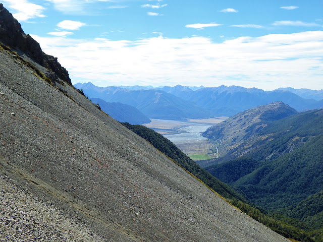
Due to hooligans, 4WD access to the reserve is now prohibited so you need to park on Lyndon Road and walk in - an extra 2km on the round trip. We arrived to a frosty start just after 8am but soon warmed up as the sun rose and energy expended. It's a steady climb up the valley to Point 936m before turning left up another valley and following the river up before turning uphill and making for the ridge. This was quite a steep scramble through scree, patches of bush and tussock but once on the ridge, fairly easy going for a while.

The first ridge and reason it's called Red Hill - iron deposits

A steep spur awaits before attaining the final ridge and along to the Red Hill summit 

Wait, there's 2 people up there?! We really didn't expect to see anyone today (TBH it's always slightly disappointing) as this is well off the beaten track. It's a nice summit with spectacular views down to Lake Coleridge and across to Mt Cook on the South West side and across the Canterbury Plains  and down to Oamaru on the other.

Lake Coleridge with SOTA summit Peak Hill (other side of lake, left)

The predicted "Light" NorWest wind was actually gusting around 30 km/h so we found a sheltered spot in the lee and piled on the outer garments.

I got HF set up in quick time whilst Dave played SOTA spokesman and photographer for the other party on summit. As usual, he started on 40m SSB and I hit 2m FM. With a good view of the plains, I managed a quick-fire 16 contacts (a record for me) including Richard ZL4ES down in Kakanui (south of Oamaru), 218 km away.

Dave got his 4 on 40m and I worked 4 on 40m CW. A switch to 30m produced 3 Australians - very light and the wind certainly didn't help but in with the earbuds and it was much easier! For what it's worth, I use Koss "The Plug" buds - they are fantastic on noisy/windy summits as they mould to fit your ear and isolate external noise. A few calls on 20m produced nothing so, as I was getting cold, we decided to pack up and head to a sheltered spot for some lunch. A quick call on 2m just after 0000z before leaving the summit gained another 4 in the log for a total of 20 contacts on 2m.

After dropping steeply down a spur, we found a sheltered lunch spot along the ridge with great views of the mountains around us, many of which I have now summited. It's a great feeling.

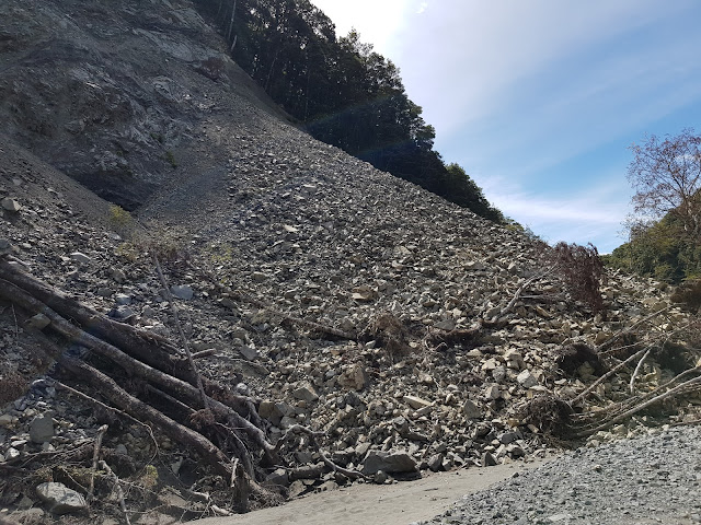
The scree Dave selected was nice and soft, it provided an excellent way to lose a lot of height quickly. There is significant erosion up there from the big weather events in 2021, at one point on the scree, a huge portion of the gut had simply disappeared - certainly keeps you on your toes.

Be careful running down the scree toward this....

As we arrived back to the bush-line at the top of the valley, the Bellbirds were out in force. Dave pulled out his caller to see if he could entice them closer and sure enough, we were visited by a couple of very curious birds. It's great to see and hear so many of them in the area.

Getting there: Drive to Lake Lyndon and turn onto the Lyndon road, pass the Lyndon Lodge (and Lyndon Lump) turnoff and park on the side of the road beside the DOC signs at -43.329548, 171.677985


Permission: Much of this route is through Brooksdale Station and permission is required.

Ascent: 6.6 km and 913m vertical gain (it's harder than these figures suggest) 2 hours 45 min. 

The circuit is 13.6km and 1019m vertical.

Sunday, 1 May 2022

Hamilton Peak ZL3/CB-267

 Located above the Broken River and Craigieburn skifields, Hamilton Peak offers great views of the alps, foothills and plains. 

Saturday 30th May forecast was for a nice Autumn day with light winds, even at 2000m so off we went, arriving at the locked gate on the Broken River access road just before 8am. First vehicle there which is always a good thing! A brisk pace up the skifield road and track soon had us at the tow base. We elected to walk up the line of the rope tow and then climb Nervous Knob to achieve the ridge that would take us to Hamilton Peak. Three quarters of the way up I decided Nervous Knob is well named... Hearing "three points of contact at all times Geoff" from Dave reinforced that this was a bit more than a hike up a hill!  Well outside my comfort zone but eventually I arrived on top and just for good measure, took a slight detour back up to the summit of the knob.

Recovery at the top of Nervous Knob!

The walk from there across the ridge to Hamilton Peak was fine (in comparison!) and we arrived at the summit 30 minutes prior to our alerted time 11am NZST. There was quite a strong Westerly wind blowing 30 km/h gusting 39 km/h so we set up in the lee of the summit where a convenient outcrop served to hold the pole and shelter us from most of the wind. Air temperature was 3 degrees Celsius (-2 to -3 wind-chill) so we got stuck in, knowing we wouldn't be hanging around too long. The temperature and wind we could handle, the ominous looking cloud coming across the alps ahead of the Nor-wester was the concern.

Looking West at the cloud building 

Following our now established pattern of Dave starting on 40m SSB and me on 2m FM, we both quickly had the requisite 4 contacts to qualify the summit including a couple of S2S. 

14 contacts on 2m FM - a great spot

I then jumped on 40m CW and worked the North Island regulars before trying 20m. No calls from VK after 3 minutes and an RBN spot. Dave was watching the weather and made the call, "we should go" so, knowing we had a long exposed ridge to traverse on the way home, we packed up quickly and set off. Total time on summit was around 35 minutes - apologies to anyone we missed.

View from the operating site. Craigieburn Ski-field in the valley (left), our descent route along the ridge (right). Mt Oxford in the far distance (left) and Castle Hill Peak/The Gap (right)

Wherever possible we choose a circuit route to avoid going back the way we come so we headed down the SE spur looking for a nice scree to join up with the Camp Saddle track back to Broken River. It was a great route with 100 m height gain. The scree selected was a ripper, long and deep - great fun!! As we jumped into it we spotted a party on Camp Saddle and speculated how jealous they would be watching us surf the scree down! The end of scree met the track and we found a nice spot to have lunch with great views down the valley and across to Castle Hill Peak and "The Gap"

Lunch view - Castle Hill Peak (centre) and "The Gap" (left)

The party of 6 we had seen on the saddle arrived for a chat, all older gentlemen led by a very sprightly 84 year-old! The walk back down took us across the last of the scree and down into the beech forest along a wide and well marked track back to the road and on to the car.

A good walk - 11.6 km and 1131m of vertical gain in the spectacular Craigieburn Forest Park Conservation Area.


Getting there: SH73 to the Broken River skifield access road. Drive in until you reach the locked gate and park (don't obstruct the gate or the other road). Walk up the road and then take the walking track to the bottom of the ski tows. From here, there is no track. Make your way up to the ridge. I don't recommend the Nervous Knob route, maybe skirt it but beware having to climb the scree!

Permission: None need, Craigieburn Forest Park Conservation Area.

Time: Ascent - 2.5 hours up (5.8 km and 1042 m vertical gain)

Cell coverage: Spark/Skinny 4G


Thursday, 28 April 2022

Coal Hill ZL3/CB-419 and Blacksmith Spur ZL3/CB-440 circuit April 2022

 I've been looking at doing these two 6 point summits as a circuit for a while. Mark ZL3AB did them first as an "out and back" in 2019 and documented it here

I managed to talk Francie into acting as shuttle driver - dropping Dave and I off at the start point of the Coal Hill track easement at 8am on a frosty April morning. That necessitated a 5am alarm but as a bonus, she got to spend the day shopping in Ashburton with her mother. Good deal!

The track starts through farmland across a couple of small gullies and then a steady climb to Coal Hill summit. It's a well marked route (poled) but basically you simply follow the fence-line straight up a spur to the summit. We were on the top in 2 hours, only stopping to chat to a couple of hunters stalking Tahr just below the summit. We exchanged planned routes and moved on to set up on a sunny but still chilly summit around 10 am local time. HF antenna was the 44' doublet and on 2m, the Signal Stick 1/4 wave with counterpoise ("rats tail"). 2m was line-of-sight to Christchurch so I qualified the summit quickly on 2m (including summit-to-summit with Ian ZL3GIG on Saddle Hill) while Dave hit 40m SSB. Once Dave had worn out 40m, I took over and worked the ZL chasers on 40m CW before switching to 20m. Caught up with the usual VK team and then a mini-pileup of Europeans ensued with Finland, France and The Netherlands in the log in quick succession - happy days! 

Conscious of the need to keep moving (and the fact that my fingers were frozen) we packed up and headed across the ridge towards Blacksmith Spur. Plenty of gunshots echoing around the valley - hopefully our mates had got onto their target species!

Looking back along the ridge to Coal Hill

The ridge has about 280m of vertical included but we made good time and were on the next summit 30 minutes early at 12:30 pm local. A convenient boundary fence post supported the antenna and we were away again with plenty of contacts back to Christchurch on 2m and NZ and Australia on 40/20m. 

Mt Cook, Mt Tasman and friends from Blacksmith Spur

We chose our operating positions on both summits to ensure we were inside the Mt Peel/Waikari Hills Conservation Area ZLFF-0022 and it paid off as we worked a number of VK stations chasing the WWFF reference which adds to the enjoyment. 

6m pole bungeed to the post 44' doublet antenna and open wire feeder.

Conscious of Mark's warning about the state of the return track down through Rawle Gully, we grabbed a bite of lunch and set off down. The first part is straightforward, follow the park boundary fence down the spur towards the gully. The last bit is near-vertical and, combined with wet grass and mud, very slippery. Both of us ended up on our backsides and ended up holding onto the fence most of the way down!

Hanging on to the fence was a good option down here...

The entry point into the riverbed is well marked but poles are a bit sparse after that and after some bush bashing, we found the markers again just before arriving at the exit point and our ride home! It's a good 2 hours down from the summit.

A really good day out. 12 points in the bag, 12km and 1360m of vertical into the legs.

Getting there: Past Peel Forest and into the Rangitata Gorge Road. Drive past two "Z" corners and along a straight to the Coal Hill track start (DOC Sign). -43.755163 171.159353

Climb is 2 hours to Coal Hill (DOC sign says 3 hours), 3.2km and 1074m vertical gain.

Ridge to Blacksmith Spur is 1 hour 15 minutes, 4km and 276m vertical

Descent from Blacksmith Spur to Rawle Gully bridge took us 2 hours (wet), 4.6 km and 992m descent

Cell reception is patchy on both summits. Sometimes 4G and sometimes not even SMS.


Thursday, 21 April 2022

Castle Hill Peak ZL3/CB-241 18 April 2022

This is a peak I have been building up to for some time and finally it all came together on Easter Monday - good weather, Dave back from holiday and me nicely warmed up with a steady run of activations under my belt.

We arrived at the start point - the top of Porters Pass on SH73 at 7:45am to find 10 cars there already... Briefly considered changing to Hamilton Peak but decided to stick with our plan and hope that the others were only going as far as Foggy Peak. As it turned out, that was a good decision.

Packs on and we were off with Dave warning me to pace myself (I have a bad habit of starting out too fast) as we headed up Foggy Peak to the first waypoint. The first part of the route is now poled - presumably to guide walkers down the correct spur when Foggy Peak lives up to it's name. Soon the poles gave way to a well trodden but unmarked route up the hill. Over a ripper of a false summit and then up onto Foggy Peak itself - 1 hour to the top and we have overtaken the first pair of climbers. So far so good. A quick stop to admire the always-inspiring sight of Mt Cook in the distance and off we go again, dropping down 80 vertical metres into a saddle with a large rock arrow that has been turned into a sculpture of a man - very clever.

Heading down the saddle "Rocky" at the bottom and our destination top right...

From here it's a steady climb along the main ridge towards our destination, the highest peak in the Torlesse Range and Korowai Torlesse Tussockland Park. Along this stage we met two climbers on their way down already.

The razorback ridge across to the final climb is a little intimidating but just keep your head down Geoff, be sure of your footing and across we go. Dave wants to come back here and do it again in winter - madness! 

Ridge negotiated and up the final steep climb to the top - motivation levels high and feeling pretty good. We met another bloke heading down the steep, slippery part here, looking good for having the summit to ourselves!

Before too long we arrive at a spectacular summit marked by a rather beaten-up trig - 2 hours 40 minutes, very happy with that.


Looking across the top of Mt Lyndon, Red Hill and Peak Hill to Mt Cook (centre back)

As usual, we were about 45 minutes early so got everything set up and ready to go. Antenna of the day was the 44' doublet (40-10m), a firm favourite and Mark ZL3AB had warned us there wasn't much room on the top. The pole was bungeed to a convenient waratah and we were in business.

Checking the doublet, view towards Christchurch

Dave started on 40m SSB with a big pileup while  I worked the locals on 2m FM. Switching to 20m CW everything sounded a bit flat but I worked a few VK regular Chasers plus a few who were clearly hunting us for the ZLFF-0027 WWFF park reference. I worked my way up the bands but no DX today - it turns out there had been an M4 Solar Flare just as we arrived on-summit! We made Summit-to-Summit contacts with Philip ZL1PSH (40m SSB+CW) and Richard ZL4FZ on Mt Iron. While Dave caught up with a few VKs on 20m SSB, I spotted more climbers heading across the ridge so we decided to pack up, have lunch and leave the summit to them. Timing was perfect, they arrived as we finished our lunch so after a brief chat about their intentions, Dave took photos for them and off we set.

The trip down was slippery but uneventful - walking poles are an absolute must-have for this one. As we descended the slopes of Foggy Peak, the cloud was rolling in and, once back at the car, the whole mountain was living up to it's name - covered in cloud.

A great trip - my highest mountain to date at 1998m and a real highlight of my SOTA journey.


Getting there: Park at the top of  Porters Pass SH73, head straight up Foggy peak!

Permission: not needed, Korowai-Torlesse Tussocklands Park

Time to top: 2 Hours 37 minutes with stops to chat to others and take photos

Cell/4G: Solid coverage on Spark/Skinny at the summit

Sunday, 10 April 2022

ZL3/CB-551 Russell Range (West)

 I don't normally write more than one blog for a summit but this one deserves it. As my climbing buddy was away, I decided to head back up to Russell Range  to try a new (for me) antenna configuration and check out the alternate descent route documented by Mark ZL3AB a few weeks ago. Anything that's easier on the knees is fine by me!

It's a nice enough 1 hour 40 minute (7km, 681m vertical gain) walk up a farm track to the summit. A beautiful autumn morning saw me shivering on the first bit but I soon warmed up as the elevation increased! For the first time in four visits, I met another person on the track, a hunter heading up on his quad bike (slightly jealous). Before long I was at the now familiar summit activation zone (the easement track runs through it) and got my requisite 4 contacts quickly on VHF (2m). As I was early, I tried UHF (70cm) and worked Ken ZL3OC in Timaru with strong signals. Jim ZL3ND popped up again so we worked on Fusion (C4FM), Jim using his handheld in the backyard. What was a scratchy FM contact became rock-solid audio when we switched to Fusion.

As my KX2 is still at the doctors, the little homebrew MTR3B (5 Watts CW-only) and trapped End Fed Half Wave (EFHW) were used. I usually rig this antenna as an Inverted V with the top of the pole close to the middle of the wire. I decided to try the inverted L configuration this time - theory being that getting the first section nearly vertical should improve low angle radiation on 20m - where the DX hangs out!

MTR3B, Tuner and tiny 450mAH LiPo

Trapped EFHW showing near-vertical first section. Track markers have many uses!

I worked the local ZLs on 40m with good signals. It was nice to work Philip ZL1PSH again from his Manukau Heads summit ZL1/AK-014. He's really getting the hang of this CW lark! Moved up to 30m and called CQ for 10 minutes - crickets... I was just about to switch to 20m and then John ZL3MR called me from Mount Barrosa ZL3/CB-499. Nice!

The antenna theory worked (or was it just a happy coincidence?) as, when I switched to 20m I had a nice pileup of VK stations and in amongst the pile, I heard "OH1". Responding "OH1?" I was thrilled to hear Pasi OH1MM calling me with a good signal in the clear. We exchanged reports and completed the contact, amazed that I was working Finland with 5W and a bit of wire -that's 17223 km!

As I was heading out the long way, I packed up HF about 11:30am and settled down to eat. With that the hunter I saw earlier came back down the track and stopped to chat. He asked the usual questions about what I was doing and seemed suitably impressed. Off he went down the steep, slippery track on his quad (I would rather be walking down...) and I had my lunch, listening to the stags roaring over in the Thirteen Mile Bush. Caught up with the locals on 2m after UTC rollover and was pleasantly surprised to get a call from John on 2m from Mount Barrosa. A bit scratchy but good enough - even with Mount Hutt right between us!


I headed down at 12:15pm local time with a big smile on my face - a very successful activation behind me and looking forward to the alternate descent route. 

It was exactly as Mark described, a very nice walk through Beech forest down the spur to the Benmore Hut. Rough and lots of windfall in places to add to the challenge of staying on the track but OK. Still plenty of wasps about so be careful if off the track... 

Nice dappled-light section soon after entering the bush at the top

Once down at the Benmore Hut junction, you turn right and follow a well marked )and well pest-trapped) track back down to the Annavale Track junction and back out to the car. This section is pretty boggy in places and you cross a few streams, waterproof boots are a plus!

A much more interesting route than coming back down the farm track, this will be my default descent route for future activations of this very nice summit. It's an extra 2 km and 107m of climbing but well worth it. 2 hours 15 minutes from the summit to the car for me this way.

Thanks to all the Chasers and fellow Activators, local and DX - every call is appreciated!

Sunday, 27 March 2022

ZL3/CB-471 - un-named summit behind Woolshed Hill

Continuing our tour around the Craigieburn/Cass/Arthurs Pass area summits, Dave and I decided to tackle this un-named summit beyond Woolshed Hill, just across the river form Mt Horrible and Mt Bruce. Mark ZL3AB did the first activation of this hill in May 2021 so I will try not to duplicate the photos here.

Arriving at the start point of the Hawdon Shelter at 8am on a crisp autumn morning, we headed on up the first stretch which, as Mark pointed out, is a very quick gain in altitude indeed! Apart from the steepness, the thing that stands out is the massive predator trapping program going on, there are box traps every few metres right up to the Woolshed Hill summit and then PVC tunnel rodent/stoat bait stations beyond that right up to the base of our summit. Efficacy is born out by the abundant birdsong all the way up.

Emerging from the bush and getting on up the scrub, tussock and shingle sections you pass a nice wee tarn (pictured in Mark's blog) and then start climbing again to the Woolshed Hill summit. Extensive  patches of snow berries (Gaultheria depressa) provided a nice protein and vitamin C boost. This summit is a nice spot and is where most people stop however the SOTA peak is beyond so off we go, losing 100m of the hard earned height in the saddle before gaining it again up to the summit of  CB-471. A big bonus on this part of the climb was being checked out by a pair of young Kea. They circled high above us descending slowly until they were only about 15m above us. Fantastic sight.

The views are expansive across the Hawdon to the main divide, South West to the Craigieburn Range - everywhere! Here's the panoramic view.


We knew there was no line of sight to Christchurch for 2m so brought the 44' open wire fed doublet along (the open wire feed and the 2m Slim Jim don't play nicely together). This antenna is a firm favourite; tunes easily and efficiently on all bands 40-10m, is easy to erect and most importantly, produces lots of DX contacts.

Dave with the doublet on 6m pole. View up the Hawdon river

It soon proved itself again with Dave running a nice pileup on 40m SSB while I yelled into the ether on 2m... To my great surprise, Stuart ZL3ART called me with a good signal. being in Hillsborough, he is not elevated so a remarkable contact.

By now, Dave had run out of contacts so, after a nice S2S with Phillip ZL1PSH on Moir Hill, I hit the CW end of the band and worked our loyal gang of Chasers. Changing to 20m I was called by Chris F4WBN with a genuine 599 signal. We exchanged reports and completed the contact - 19,500km! Made my day. The higher bands produced plenty of VKs including an S2S with Peter VK3ZPF (author of VK Portalog) and a few JA contacts.

We decided to have lunch on the summit as there was very little breeze and terrific views

Nice lunch spot looking up the Hawdon River valley

Across the Waimakariri River to Mt Horrible (L) and Mt Bruce(R)


Heading down was uneventful - we ran into two couples heading up to Woolshed Hill and there was quite a crowd of vehicles back at the shelter - the Hawdon Hut was probably going to be fairly full!

Cell/4G coverage at the top was OK on Skinny/Spark and patchy on Vodafone.

Repeaters - None available

Time: 2.75 hrs up and 2.5 down

Permission: None needed - Arthurs Pass National Park (ZLFF-0002)

Access: Park/start at the Hawdon Shelter, across the Mt White Station bridge on SH73

Wednesday, 9 March 2022

Mt Bruce ZL3/CB-416 March 2022

 After three weekends off SOTA due to weather (1) and contests (2), I was keen to get out for a walk! The weather looked good so Dave ZL3DRN and I decided to head to Mt Bruce in the Craigieburn Forest Park Conservation Area ZLFF-0024 - just a bit further along than Mt Horrible which we did earlier in the year.

The morning dawned foggy which is always a good sign. We were keen to get an early start to get up before the heat of the day and a forecast Nor West change in the afternoon so left home at 6am, picked up Dave at Sheffield and arrived at the Cora Lynn Road DOC carpark just before 8am. There were plenty of cars there already but this is deceiving as it is the terminus of the Cass-Lagoon Saddle track. Dave assured me they wouldn't be heading for the summit and so it proved.

Heading off up the well marked track, the going is pretty easy until you emerge from the bush (manuka and beech) and strike off up the slope towards the ridge. We had 4 Kea above us at this point - a great sight. There's no track from here so it's a matter of tussock bashing your way up a fairly steep grade. Lots of micro-rests (to admire the view you understand...) were required on the way up but before too long, we arrived at the ridge and made our way along to the summit. Spectacular views abound. The weather was great with just a  light breeze. As we surveyed the horizon, big fluffy cumulus were already forming out towards the West and we resolved to keep an eye on them.

Nearly there...

There's no trig, just a pipe sticking out of the ground which was perfect to bungee the pole to. We were about an hour early (now there's a surprise!) so we took our time setting up the gear and had a look around. Mt Horrible looked quite insignificant from this altitude! We spotted a couple down in the saddle moving towards the summit and just as we started calling on 2m and HF, they arrived. Very fast, fit and carrying a hunting bow and substantial packs. We took a few moments to chat and they revealed that they had not had any luck hunting but were thoroughly enjoying the scenery and the walk.

I had modelled the VHF coverage using the excellent VE2DBE website and it had shown a very poor chance of any contacts back to Christchurch. However Mark ZL3AB was activating up near Hanmer so we set up the 5/8 wave Flowerpot on the mast to give it a try. I couldn't trigger any of the Canterbury repeaters but heard 147.05 about S3.


Looking West up the Bealey River towards Arthurs Pass.

Meanwhile Dave was plugging away on HF and got his 4 contacts on 60m and 40m including Warren ZL2AJ on Tuhua ZL1/MW-071. I worked Warren too and then hit the CW end of the band and picked up another S2S with Andrew VK1AD on Mt Coree VK1/AC-023. John VK4TJ and Andre ZL1TM rounded out my 4. A bit of a battle for a change! I moved to 20m and worked Peter VK3PF and Gerard VK2IO. With that, the first puff of Nor West hit us so we conferred and decided to pack up and head down off the summit into the top of the valley for lunch. Just as we switched off we got an alert that John ZL3MR was on a summit and calling. Switching the gear back on we found him with a good 40m signal from Mt Lyndon ZL3/CB-460. With John in our logs and no spots for/from Mark, we packed up and headed down the ridge to find a suitable scree for a rapid (and fun!) descent. 

Waimakariri River, SH73 snaking round Mt Horrible and some nice scree!

We moved down the stream from it's source until we found the start of the old Broad Stream track. It's still well marked with plenty of orange triangles but it is not shown on the current topo maps. It was a nice sheltered spot so we stopped and had a 30 minute lunch break with nice views right down the valley to Mt Horrible and Woolshed Hill.

Lunch - Mt Horrible slopes on the right, Woolshed Hill on the left

Track entrance, back into the Beech and out of the hot sun!

On with the packs and down the track. There are several sections where the track has been washed out or covered with slips so you need to keep your wits about you and search carefully for the next marker. Failing that, just following the stream down will do although there would be a lot of boulder hopping required.

There's an orange triangle under that lot...

At the bottom end of the valley you can either climb a bluff and follow triangles across to the carpark in the conservation area, cross the paddock (with prior permission from Cora Lynn Station Wilderness Lodge) or carry on down to the SH73 bridge and walk back along the highway and up Cora Lynn Road. Don't try a hybrid of the first two options like we did, I am still picking gorse spikes out of my hands...

Boulder hopping in the lower section

A big day and a very nice summit - highly recommend this one to fit activators.

Getting there: head on SH73 to Cora Lynn Road, go through the gate to the DOC carpark

Permission: None required however asking about crossing the paddock will make the end of the day easier!

Walking: 11.2 km circuit with 1100m of vertical gain

Times:  2 hours 40 min to the summit. About 3 hours for the exit via Broad Stream (inc. 30 mins for lunch).

2m coverage: Nil

Cell: patchy but 4G coverage on the summit VF and Spark/Skinny