Sunday 27 March 2022

ZL3/CB-471 - un-named summit behind Woolshed Hill

Continuing our tour around the Craigieburn/Cass/Arthurs Pass area summits, Dave and I decided to tackle this un-named summit beyond Woolshed Hill, just across the river form Mt Horrible and Mt Bruce. Mark ZL3AB did the first activation of this hill in May 2021 so I will try not to duplicate the photos here.

Arriving at the start point of the Hawdon Shelter at 8am on a crisp autumn morning, we headed on up the first stretch which, as Mark pointed out, is a very quick gain in altitude indeed! Apart from the steepness, the thing that stands out is the massive predator trapping program going on, there are box traps every few metres right up to the Woolshed Hill summit and then PVC tunnel rodent/stoat bait stations beyond that right up to the base of our summit. Efficacy is born out by the abundant birdsong all the way up.

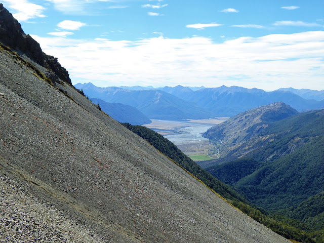
Emerging from the bush and getting on up the scrub, tussock and shingle sections you pass a nice wee tarn (pictured in Mark's blog) and then start climbing again to the Woolshed Hill summit. Extensive  patches of snow berries (Gaultheria depressa) provided a nice protein and vitamin C boost. This summit is a nice spot and is where most people stop however the SOTA peak is beyond so off we go, losing 100m of the hard earned height in the saddle before gaining it again up to the summit of  CB-471. A big bonus on this part of the climb was being checked out by a pair of young Kea. They circled high above us descending slowly until they were only about 15m above us. Fantastic sight.

The views are expansive across the Hawdon to the main divide, South West to the Craigieburn Range - everywhere! Here's the panoramic view.


We knew there was no line of sight to Christchurch for 2m so brought the 44' open wire fed doublet along (the open wire feed and the 2m Slim Jim don't play nicely together). This antenna is a firm favourite; tunes easily and efficiently on all bands 40-10m, is easy to erect and most importantly, produces lots of DX contacts.

Dave with the doublet on 6m pole. View up the Hawdon river

It soon proved itself again with Dave running a nice pileup on 40m SSB while I yelled into the ether on 2m... To my great surprise, Stuart ZL3ART called me with a good signal. being in Hillsborough, he is not elevated so a remarkable contact.

By now, Dave had run out of contacts so, after a nice S2S with Phillip ZL1PSH on Moir Hill, I hit the CW end of the band and worked our loyal gang of Chasers. Changing to 20m I was called by Chris F4WBN with a genuine 599 signal. We exchanged reports and completed the contact - 19,500km! Made my day. The higher bands produced plenty of VKs including an S2S with Peter VK3ZPF (author of VK Portalog) and a few JA contacts.

We decided to have lunch on the summit as there was very little breeze and terrific views

Nice lunch spot looking up the Hawdon River valley

Across the Waimakariri River to Mt Horrible (L) and Mt Bruce(R)


Heading down was uneventful - we ran into two couples heading up to Woolshed Hill and there was quite a crowd of vehicles back at the shelter - the Hawdon Hut was probably going to be fairly full!

Cell/4G coverage at the top was OK on Skinny/Spark and patchy on Vodafone.

Repeaters - None available

Time: 2.75 hrs up and 2.5 down

Permission: None needed - Arthurs Pass National Park (ZLFF-0002)

Access: Park/start at the Hawdon Shelter, across the Mt White Station bridge on SH73

Wednesday 9 March 2022

Mt Bruce ZL3/CB-416 March 2022

 After three weekends off SOTA due to weather (1) and contests (2), I was keen to get out for a walk! The weather looked good so Dave ZL3DRN and I decided to head to Mt Bruce in the Craigieburn Forest Park Conservation Area ZLFF-0024 - just a bit further along than Mt Horrible which we did earlier in the year.

The morning dawned foggy which is always a good sign. We were keen to get an early start to get up before the heat of the day and a forecast Nor West change in the afternoon so left home at 6am, picked up Dave at Sheffield and arrived at the Cora Lynn Road DOC carpark just before 8am. There were plenty of cars there already but this is deceiving as it is the terminus of the Cass-Lagoon Saddle track. Dave assured me they wouldn't be heading for the summit and so it proved.

Heading off up the well marked track, the going is pretty easy until you emerge from the bush (manuka and beech) and strike off up the slope towards the ridge. We had 4 Kea above us at this point - a great sight. There's no track from here so it's a matter of tussock bashing your way up a fairly steep grade. Lots of micro-rests (to admire the view you understand...) were required on the way up but before too long, we arrived at the ridge and made our way along to the summit. Spectacular views abound. The weather was great with just a  light breeze. As we surveyed the horizon, big fluffy cumulus were already forming out towards the West and we resolved to keep an eye on them.

Nearly there...

There's no trig, just a pipe sticking out of the ground which was perfect to bungee the pole to. We were about an hour early (now there's a surprise!) so we took our time setting up the gear and had a look around. Mt Horrible looked quite insignificant from this altitude! We spotted a couple down in the saddle moving towards the summit and just as we started calling on 2m and HF, they arrived. Very fast, fit and carrying a hunting bow and substantial packs. We took a few moments to chat and they revealed that they had not had any luck hunting but were thoroughly enjoying the scenery and the walk.

I had modelled the VHF coverage using the excellent VE2DBE website and it had shown a very poor chance of any contacts back to Christchurch. However Mark ZL3AB was activating up near Hanmer so we set up the 5/8 wave Flowerpot on the mast to give it a try. I couldn't trigger any of the Canterbury repeaters but heard 147.05 about S3.


Looking West up the Bealey River towards Arthurs Pass.

Meanwhile Dave was plugging away on HF and got his 4 contacts on 60m and 40m including Warren ZL2AJ on Tuhua ZL1/MW-071. I worked Warren too and then hit the CW end of the band and picked up another S2S with Andrew VK1AD on Mt Coree VK1/AC-023. John VK4TJ and Andre ZL1TM rounded out my 4. A bit of a battle for a change! I moved to 20m and worked Peter VK3PF and Gerard VK2IO. With that, the first puff of Nor West hit us so we conferred and decided to pack up and head down off the summit into the top of the valley for lunch. Just as we switched off we got an alert that John ZL3MR was on a summit and calling. Switching the gear back on we found him with a good 40m signal from Mt Lyndon ZL3/CB-460. With John in our logs and no spots for/from Mark, we packed up and headed down the ridge to find a suitable scree for a rapid (and fun!) descent. 

Waimakariri River, SH73 snaking round Mt Horrible and some nice scree!

We moved down the stream from it's source until we found the start of the old Broad Stream track. It's still well marked with plenty of orange triangles but it is not shown on the current topo maps. It was a nice sheltered spot so we stopped and had a 30 minute lunch break with nice views right down the valley to Mt Horrible and Woolshed Hill.

Lunch - Mt Horrible slopes on the right, Woolshed Hill on the left

Track entrance, back into the Beech and out of the hot sun!

On with the packs and down the track. There are several sections where the track has been washed out or covered with slips so you need to keep your wits about you and search carefully for the next marker. Failing that, just following the stream down will do although there would be a lot of boulder hopping required.

There's an orange triangle under that lot...

At the bottom end of the valley you can either climb a bluff and follow triangles across to the carpark in the conservation area, cross the paddock (with prior permission from Cora Lynn Station Wilderness Lodge) or carry on down to the SH73 bridge and walk back along the highway and up Cora Lynn Road. Don't try a hybrid of the first two options like we did, I am still picking gorse spikes out of my hands...

Boulder hopping in the lower section

A big day and a very nice summit - highly recommend this one to fit activators.

Getting there: head on SH73 to Cora Lynn Road, go through the gate to the DOC carpark

Permission: None required however asking about crossing the paddock will make the end of the day easier!

Walking: 11.2 km circuit with 1100m of vertical gain

Times:  2 hours 40 min to the summit. About 3 hours for the exit via Broad Stream (inc. 30 mins for lunch).

2m coverage: Nil

Cell: patchy but 4G coverage on the summit VF and Spark/Skinny