Wednesday, 4 March 2020

Cloudy Hill ZL3/CB-474 and ZL3/CB-469 1st March 2020

David ZL3DRN suggested we have a crack at these two 4 pointers - the first day of Autumn turned out to be a fine, calm Sunday. We alerted for 9am local time to the first peak and warned that we wouldn't hang around long there so as to be on the second summit before the heat of the day.
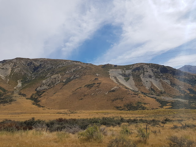
View from the roadside. Spur in the foreground, peak on the left.

Cloudy Hill is within the Korowai/Torlesse Tussocklands Park however to access it from the State Highway, you need to cross private farmland - please make sure you ask for permission first.
The climb (no track, gps advised) takes you up a spur and ridge to the summit, about 1 1/2 hours with a few rest stops to admire the spectacular views.
Antennas set up and ready to go, 2m Slim Jim 1/2 way up pole and HF endfed at the top. Porter Heights skifield in the basin, behind/left.

We had decided that David would operate 2m upon reaching the summit and I would set up the pole and HF gear and then I'd grab 2m while David started HF. For a while we looked in danger of not activating on 2m - Don ZL3DMC was quickly in both our logs but there was no-one else around... I went to 40m and worked John ZL1BYZ and Jacky ZL1WA on their Manukau Heads summit ZL1/AK-014 , that's three in the log...A txt to Rick ZL3RIK and Geoff ZL3QR soon got things moving on 2m and we also worked John ZL3MR who was still climbing Mt Grey ZL3/CB-673. Robin ZL3REW and Gavin ZL3GAV called in and it was time to go.

We packed up and were walking again by 10am, 30 minutes after we'd budgeted for but OK.

Looking East to Christchurch

Looking down to Lake Lyndon and Trig M ZL3/CB-536 behind

We made good time and arrived at the second summit only a few minutes after the alert time of 11am Local. We used the same setup strategy again and this time activated quickly on 2m FM. Moving to HF produced John and Jacky again and also John ZL3MR, now on his Mt Grey summit - a good haul of S2S points. HF CW was disappointing, only producing one VK, Allan VK3ARH, Rick ZL3RIK  and Andre ZL1TM. I called CQ on 30m and 17m with no RBN spots or contacts - very rare. At that point we called it quits, packed up the gear and enjoyed our lunch perched on the edge looking out over at Mt Lyndon.
Red Hill ZL3/CB-411 (Left) and Peak Hill ZL3/CB-542 with Lake Coleridge through the valley.


David has a healthy dislike of returning via the same route so we came out via a couple of excellent scree runs and then bush-bashed our way down the valley. One of the day's highlights was the Chamois that popped up about 20m in front of us, took off up the spur and watched us from the ridge. Magic stuff!

Chamois on the ridge making sure we were leaving!

After bashing/crawling through acres of Matagouri (well it felt like that at the time!) we emerged onto the grazed paddocks and made our way back down to where we'd left the car.
A fantastic adventure full of highlights: 8 points in the bag, great views and company, seeing my first wild Chamois and home in time for family dinner!

Gear - 2m: FT-270R with roll-up Slim Jim 3m up the pole, HF: KX2 with QRPGuys 41' UNUNTenna and 35' counterpoise.

Access: Contact farmer for permission to cross his land into Korowai/Torlesse Tussocklands Park
VHF: good coverage of all CHC repeaters and simplex
Height gain 911 m
Distance 9.5 km
Time: 7:40 total

Tuesday, 25 February 2020

Mt Richardson ZL3/CB-612 23 Feb 2020

This was my second time up Mt Richardson in North Canterbury.
The night before we had a Southerly change and snow down to 1500m, in mid-February!
View of the mountains from Tram Road - this IS summer right?!
It's a moderately steep climb up an excellent DOC track. There's a diversion after a few minutes which takes you to a nice waterfall viewpoint. The track carries on and rejoins the main track. Native bush shelters you pretty much all the way and then at the summit, you emerge to the sunshine and spectacular views over Lees Valley, Canterbury Plains and of course the Southern Alps. Lots of birdsong from the Bellbirds, flitting from the Fantails and whooshing from the Kereru to keep you company :-)
Nice views - what's that white stuff doing there in February!
I was up there nice and early, got set up and worked the loyal CHC chasers on 2m FM including Geoff ZL3QR who achieved first QSO status again from an equestrian event in the Waimak Gorge.
HF was up and running quickly using the usual 41' endfed and KX2. I was rewarded with S2S contacts with John ZL1BYZ, Jackie ZL1WA and Warren ZL2AJ. I also discovered that doing SOTA on JW Field Day is a mixed blessing... Probably enough said about that! I headed down at noon and visited the ZL3RR Branch 68 site at View Hill. They had a very slick operation running and were very happy having doubled their previous year's score.


Directions: From the Glentui picnic area at the end of Glentui Bush Road, follow the well-marked and well-used walking track to the summit
Time to summit: 2hr 15min
Summit marker: Trig
Land access permission: Not required, Mt. Thomas Forest Conservation Area
Repeater access: good to all Christchurch area repeaters
Cellphone access: Patchy Spark coverage on the summit


Sunday, 9 February 2020

Otanewainuku ZL1/BP-193 Feb 2020

Francie's Dad lives in Whakatane and we visit for a few days each year. Last year I had intended to activate Mt Maunganui but it was Easter Sunday and as it is one of the few places in the country open on that day, it was jumping with tourists!

This year was better planned and after a fantastic couple of days fishing, Francie and I set off to Te Puke on Saturday to activate this Bay of Plenty summit.

Warren ZL2AJ and family did all the hard work on the initial activation and documented it well on his blog. Please get the access details and how to find the true summit (it's not the trig) etc from there, I'll just add a few observations and photos.

It's a very nice walk in native bush all the way. One of the best marked tracks I've been on. Lots of native birdsong including Kiwi! A really nice experience hearing them in the wild for the first time.

We arrived at the summit which is densely bush-clad, a strange thing for a Canterbury lad used to alpine tussock and bare rock! I set up the pole with the 41' endfed UNUTenna however it was very tricky to erect far enough away and I ended up doubling back around a branch to the operating site. One learning from this is to take a 25' wire to known bush-clad summits in future, easier to manage. It will mean no 80m or 60m however.
Antenna wire coming towards camera around branch and back up behind to pole!

I found Chris ZL4RA with a good signal on 20m SSB for an S2S and then back to 40m SSB and qualified the summit. I knew getting Warren ZL2AJ and John ZL1BYZ in the log was going to be  a challenge as they were too close. 80m, 60m and 40m were no good, I finally worked John (and Andre ZL1TM) on 20m CW and unfortunately Warren and I couldn't make it. I am sure my compromised antenna setup and being surrounded by bush didn't help. Reports received were consistently low.
I worked Allen VK2ARH S2S (20mCW) and Gerard VK2IO (17mCW) and that was it, 9 QSOs, 2 S2S.

It's a very popular track and we made sure we were off to the side. 6 parties came past and Francie adeptly explained what we were doing. One lady was keen to learn more and we had a good chat.

In summary, it's a nice, relatively easy walk but quite a challenge to activate. A good challenge!

There is a lot of work involved in maintaining this piece of paradise - community and DOC partnership seems to be very effective. Lots of bait stations (pink markers) targeting predators
The giant Kahikateas are magnificent, friendly North Island Robins come right up close and plenty of Kereru (Wood Pidgeon) and Tui around too.
One of NZ's tallest trees, a 40m high Kahikatea (White Pine)


 We visited the trig platform on the way down and took the obligatory panorama photo (the posts are the four corners of the elevated platform)


I'd highly recommend this summit to visitors, it's a great taste of classic Kiwi (literally!) bush.

73
Geoff ZL3GA


Wednesday, 22 January 2020

Flag Peak ZL3/CB-737 18th January 2020

This is my third activation of Flag Peak but first blog. It's one of those hills that grows on you, I didn't particularly enjoy my first activation of it, I left the track too early (twice!) and ended up covered in scratches from Spaniard and Gorse. This time it was a doddle, great weather and I had Francie along with me.

Looking down at Akaroa and a visiting cruise ship
Mark ZL3AB was activating Mt John (Observatory) and there was a relatively unobstructed path so I decided to take my portable 2m 3 element yagi. Lucky there wasn't many branches overhanging the track!


Upon arriving I set up the yagi and climbed right to the summit to try our luck south, unfortunately nothing heard either way, maybe if we had gain antennas at both ends? I did work David ZL3DRN on Red Hill and Ian ZL3GIG on Lavericks, 59+++ both ways unsurprisingly!
Why is that Madman waving a TV antenna around?!


HF was set up quickly and a quick 40m CW contact with Mark on 40m had us both smiling.
Tactical Mini pole to left (North) of me, nice rock for me to perch on.
 
Usual setup, KX2, QRPGuys UNUNTenna with 41' wire and 35' counterpoise
This is a spectacular summit, thoroughly deserving of a panorama ;-)
It's so good you suddenly realise that you are seeing in real-time what you have seen since childhood on maps of Banks Peninsula.

Francie had her book and was enjoying the sunshine so we stuck around for the 1pm UTC rollover.
Looking East - next landmass is Chile! Francie in right of picture enjoying the view and her book.

An uneventful packup and walk down, followed by a very nice lunch in Akaroa and home!

How to get there:
Drive to Akaroa and head (carefully) up Stony Bay Road to the Misty Peaks Carpark at the top. Walk back down the road 100m to the track start. Walk well past the peak to where the track turns left and at the gate, turn left and walk up the spur to the summit.
Easy 30 minute walk, 190m altitude gain.
Permission, none needed, Armstrong reserve.

Sunday, 5 January 2020

Mt William ZL3/WC-573 New Years Day 2020

This is a really nice mountain, close to Westport where we spent our summer holiday. Mt Rochfort is nearby too but has a longer 4WD track to access - next time.
Weather forecast was Ok for the morning and early afternoon with a very light SW but a change to Westerlies and rain forecast for the afternoon.

The mountain is accessed from the historic mining area of Denniston Plateau, a destination worth visiting in it's own right (I took Francie back there the following day). "Myra's track" starts opposite the Coalbrookdale walk entrance and is a marked bush track but you need to keep your wits about you as it is easy to lose.

Track start at Coalbrookdale

Main bit to watch is not far from the start where you emerge onto a MTB road and it is not clear where Myra's track restarts on the opposite side. I cast around for a while before finding it

Track continues up to right of the MTB track to the right of the three boulders (red arrow)
It's a good climb, the sign says 2 hours and that's what it took me with a couple of breaks. The climb is quite technical in places, it's not just a walk up a hill. There are quite steep sections with limited foot/hand holds. Care required as there is a lot of moss around (I slid down a bit on my backside coming down).

A very old trig marks the summit. Activation zone is large with plenty of room to set up.

I chose to use an overhanging boulder as shelter from the sun so ended up with a fairly unique set-up.
Pack used to keep wire off the rock which seemed to help tuning! Yellow wire is counterpoise.
Scenery was spectacular as you expect on the West Coast - Denniston Plateau and Tasman Sea on one side and mountains around the remainder

I fired up the KX2 on 40m SSB and worked a bunch of other activators and NZART activity day stations. Knowing that Mark ZL3AB was going to be tricky on anything but 60m (he was only 90km away but the other side of the alps) I went there and worked some Christchurch chasers and then Mark popped up with an excellent signal! 30m was next and worked Dan ZL4DVG on a neighbouring West Coast summit and then headed to 20m for VK1MCW, VK4TJ and VK2IO/P.
A few more on 40m and at 2330z I noted the cloud rolling in from the Tasman Sea and wind rising.
I decided to have lunch and be ready to work a few after the rollover and then pack up and get down the track. This strategy worked well as by 0008z I had 6 contacts in the log and it was time to go.

Descent was OK apart from the above-mentioned slide and slight worry about losing the track in low cloud, dense bush and with a low cellphone battery... Next purchase will be a dedicated GPS unit!

Mt William is a nice summit and I'd recommend visitors to Westport activate it.

Getting there:
Drive to Denniston (30 mins from Westport) and take the Burnetts Face Road (shingle but OK for 2WD) to the start of Myra's Track (Coalbrookdale Walk is right opposite). Park just before the bridge and walk over it to find the track start. There is another parking area available: instead of taking the hairpin turn, go straight ahead and park. 5 min walk back to trail head - better option for Campervans!
Permission not needed - conservation land but be aware this is still an active mining area, watch for trucks.
4G coverage (Spark) on the summit and Westport National System Node (I could trigger the tail but no-one heard audio from me - maybe faulty)
Time: 2 hours ascent (with breaks), 1 hour descent.


Thursday, 26 December 2019

ZL3/CB-551 West Russell Range - 26 December 2019

Needing to blow the cobwebs out on Boxing Day, I headed to this one I have had my eye on for a while. It has a new DOC easement track (no bikes, dogs or hunting) through Ben More and Annavale stations, near Springfield.
The day dawned with low cloud but no wind so job was on! There are two car-parks, one for 2WD vehicles and for those with a (proper) 4WD, you can carry on and save yourself 30 minutes walk. I decided not to take Francie's nice new Suzuki along it, very deep ruts and lots of water-filled holes...

The track junction, turn left over the stile.
Steady climb but soon hit the low cloud!
Looking across the valley to Big Ben Range - it's there somewhere!

Looking back down towards North Canterbury

Nearly at the summit. This Link Track could be a good option to stay at Benmore Hut and attempt Big Ben the next day? And it was nowhere near 1.5 hours on to the SOTA summit (1211m vs Sugar Loaf at 1203m)

It's up there somewhere!

Made it. As this summit is not on the DOC easement track, I only popped up there for a photo and VHF contacts
The track wends it's way through the Activation Zone so after working the locals on 2m, I tied my 6m pole to a handy DOC waratah track marker and set up on HF. Pretty average conditions but I did work a few VKs including Allen VK3ARH S2S. Highlight of my day was having Ian ZL3GIG call me on 40m CW S2S - his second ever CW QSO, I suspect he is now hooked :-)
After an hour of operating the Easterly wind came up and was blowing the cloud around and cooling me down. I packed up, ate my lunch and headed down. Take walking poles on this one, the track is quite slippery with scree at times.

Wild pigs have been busy near the summit....
Getting there: 12km past Springfield look for the turnoff to Ben More Station. Turn left and drive down, across the bridge and turn right at the end of the road. There are reassuring DOC signs around. Drive to the car-park and off you go. Track is well marked with waratahs. Private property gates are also well marked!
Time: It's about a 2 hour climb (from the 2WD car-park), 7.24km and 681m height gain.
VHF - good to Christchurch, North Canterbury and Rakaia


Sunday, 15 December 2019

Mt Lyndon ZL3/CB-460 14th December 2019

I'd admired Mt Lyndon whilst activating it's neighbours, Trig M CB-536 and the "Lyndon Lump" CB-570. When David ZL3DRN invited me to join him on the inaugural activation of this peak, I accepted eagerly. At 1489m it would be my highest peak yet so a good challenge.

Mt Lyndon seen from Trig M (June 2019)


We agreed to meet early (7am at Sheffield) to beat the forecast North Wester. We arrived at Lyndon Lodge soon after and were walking by 7:40am in calm conditions. Ascent was uneventful and we made good time to the summit, arriving about 9:15am - much earlier than anticipated. We had stopped just below the summit to put on jackets and beanies as there was quite a cold breeze...

We took the mandatory summit photos and admired the spectacular views before setting up.

Me on the summit with Lake Coleridge in the background. Peak Hill CB-542 behind the lake on the left of shot.

Panorama - amazing vistas right around

Looking across to Porter Heights ski-field - Mt Enys CB-152 on the right (with snow)
David is already planning my next big challenge - Castle Hill Peak CB-241
We tried to find a spot out of the cold Nor West wind but it was not possible. Gloves and another layer on and we had the pole set up with David's UNUNTenna and KX2 ready to go.
Let's qualify it on VHF first, it'll be easy... Patchy 4G coverage meant spotting was difficult and we were much earlier than alerted. Fortunately Geoff ZL3QR heard us and we were away, thanks to Geoff, Jim ZL3ND, Gavin ZL3GAV and Rick ZL3RIK. It was nice to hear Oliver ZL3OOC call us too.
By this time, we were feeling very cold despite all our gear - looks like I left it a bit late to put the extra layers on during our ascent and should have carried all my extra merino layers - lesson learned.
As we had the HF antenna set up and knowing John ZL1BYZ would be waiting, David called CQ on 40m SSB. Sure enough, there he was! David saw me struggling to write the contact in his logbook, my hands were shaking uncontrollably and he made the (correct) call to pack up and get moving. David measured the windchill at 3 degrees C from a 20kmh Nor Wester (they certainly aren't warm in the high country!)

We packed down, had a quick snack and set off - "feel like taking the valley route back?" he asks innocently. "There are scree slopes, they are great fun". Feeling better once moving, I agreed. It wasn't until we were committed that he casually mentioned there might be swamps and oh, a waterfall to negotiate too! David was determined to get my shiny new boots dirty!

Nearing the bottom of my very first scree descent - what a rush!!

This sure beats plodding down a track!


Waterfall- spectacular but required a bit of turpentine bush-bashing to skirt it

The scree "surfing" was amazing fun and of course as we got down further, the sun came out! Negotiating the waterfall was tricky and was soon followed by chest-high matagouri, swampy ground and even a bit of beech forest thrown in. A really good way to come down but definitely not for the solo activator - you need someone with you if coming down this way.

A great summit and definitely on my "annual list".

Where: Mt Lyndon via Lyndon Lodge end track
Permission: None needed, Korowai Torlesse Tussocklands Park
Time: 1 hour 40 minutes ascent with stops (1 hour 16 moving time)
Mobile: 4G at summit (Spark) but patchy
Repeaters: all Christchurch repeaters