Saturday, 7 January 2023

Kaitoa ZL3/CB-767

New Years Day 2023 found us camping at Peketa, just South of Kaikoura. 
Most of the SOTA summits around the area are on private land apart from Mt Fyffe ZL3/CB-425. I had already arranged to activate it with Dave later in the week so, after a bit of research and a phone call, settled on Kaitoa ZL3/CB-767. It's a sugarloaf just North of the township, up the Puhi Puhi River Valley, near Hapuku. The farmer was happy for me to have access - for his contact info, email me.
New Years Day dawned fine and I was soon at the start point, parked up by the woolshed. Seeing signs of life as I walked past the house, I stopped in and met Rob. He gave me a couple of tips on the best routes up and down.
It's a straightforward walk up well maintained farm tracks to the summit. Apart from a short section of native bush, you are in open paddocks all the way.

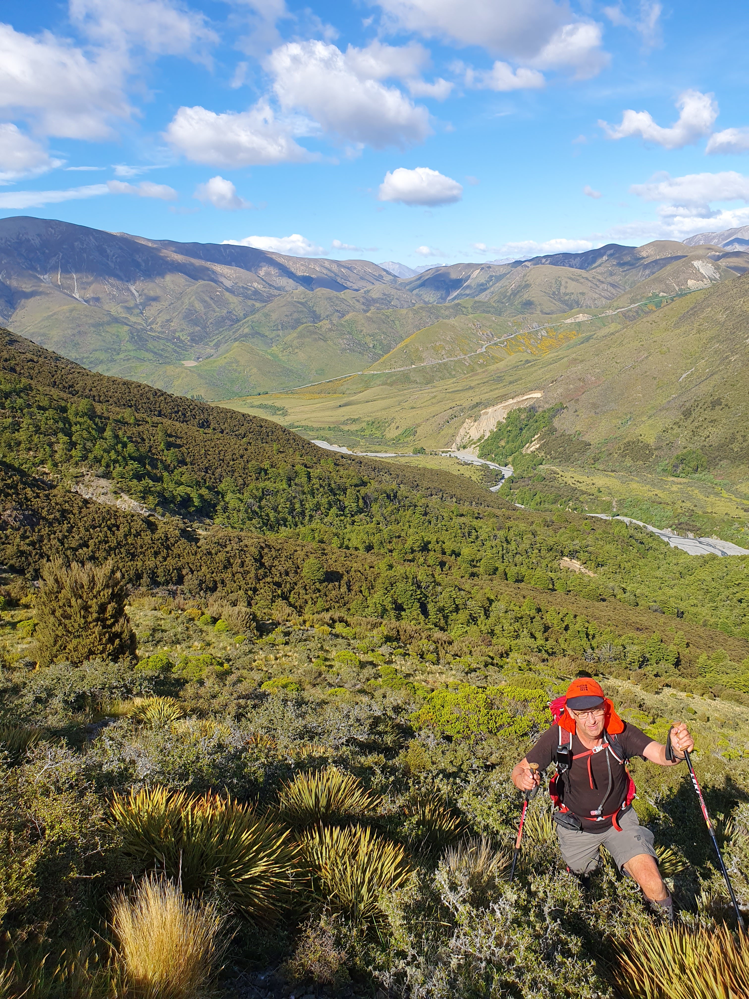
View from the summit back towards Kaikoura

You pass a substantial comms/internet installation on the way but I had no noticeable interference from it's equipment or solar regulators.


Keen on VHF contacts to Christchurch and with fairly benign (albeit cool) weather, I set up right at the top, bungeeing my pole to a convenient fence post.
EFHW and Coaxial 2m dipole on mast. 2 element Arrow yagi against trig

 
I had also taken my 3 element 2m Arrow yagi (uses a walking pole as the boom) but when assembling it, found the bottom element mount missing... Oh well, try it as a 2 element! As it turned out, it was a couple of S points better to Rick ZL3RIK on Mt Pearce than the dipole and I worked Roger ZL3RC at home in West Melton with solid signals (horizontally polarised). There was a slim chance of a contact with Brendon ZL1ALF on his summit (ZL1/WL-059 McKerrow) in Wellington. We tried a few calls each but nothing heard either way.

HF was in good shape and I had a ball working other portable operators around New Zealand and Australia. USA and Japan stations were also logged but my focus today was on Summit-to-summit (S2S) contacts, each side of the 1pm UTC rollover. Thus, I spent much more time on 40m SSB than is normal for me. The strategy paid off with 60 contacts, 29 of them S2S.

The walk down was uneventful and again, had a chat to the farmer as I went past the house.
A really enjoyable and productive New Years activation.

Access: Private land, permission required. Contact me for details.
Trig - Yes
Time: 1 1/2 hours (New years day pace...) 4.8km/676m vertical
Repeater: didn't try but 705/725 should be Ok. VHF LOS to Banks Peninsula Summits.


Sunday, 18 December 2022

ZL3/CB-534

 This un-named summit lies above Lake Rubicon just South East of the Torlesse Range. It's surrounded by private land belonging to Brooksdale Station and accessed from SH73 near the historic Roadmans Hut. Dave happens to know the station manager so permission was secured and off we set on a mild December morning. It starts with a 2km walk up the riverbed or farm track, your choice, before finding a suitable spur to climb to the ridge and along to the generous-sized 4 point summit at 1261m.

We chose the farm track and, only about 1km from the state highway, were rewarded with seeing 3 chamois nannies only 40m or so away. As we both reached for our cameras, they took off, bounding up the hill with graceful ease. A great way to start the day!

Once you leave the riverbed, the first part is tough with a bit of scrub bashing up a steep section. Once above the scrubline, it's a straightforward slog up to the ridge.

Dave climbing up through the Spaniard and Matagouri. Kowai River below and SH73 Porters Pass in the background

The summit is a good size so we were able to find some shelter from the gusty (but dry) Nor Wester on the lee (Christchurch) side. Dave started on 40m SSB and I hit 2m and 70cm. A great run and 18 contacts in the log before I returned to the HF setup. I then worked some HF CW, local and DX (2 USA and 2 JA).

Antenna (EFHW on 6m Tactical Mini) with Mt Torlesse in the background

We both had evening appointments and wanted to take a circuit route home so packed up around 1130am, had some lunch and set off along the really nice ridgeline traverse to Pt1230. We then dropped down a spur to the riverbed. More bush-bashing involved and a descent down a creek. Back across the river and down the farm track towards the car. A bee sting to my hand forced a quick stop for an anti-histamine and then back to the car. 

NE View from the ridgeline, Lake Rubicon in the middle.

Another great day in the Korowai-Torlesse Tussocklands Conservation Area (this brought up my 500th QSO for this park).

Permission: Conservation land starts above the 900m contour. Before that you are on Brooksdale Station land - permission required, contact Dave ZL3DRN for details.

Getting there: Heading West on SH73, past Springfield but before you start climbing Porters Pass, there is a layby on the right with a little red historic Roadmans Hut on the left. Park in the layby and cross the fence by the gate. Follow the farm track up the valley. GPX file is on the SOTA summits site.

Time: Ascent - 2.5 hours, 5.7km and 700m vertical gain

Descent - there are a number of options but the one we used on our second visit on 10th June 2023 is probably the best. It's on the SOTA Summits tracks page (or contact me for an emailed copy).


Mt Isobel and Dumblane double

 Mark ZL3AB and I have discussed this potential double for a while but this was my first opportunity to try it. The two mountains are opposite each other with Jacks Pass in between. Another weather window presented itself, between 30 degree days late in the week and a wet period beginning Sunday - let's do it!

Conservative as always, I allowed a couple of hours for the trip to Hanmer and 1 1/2 hours for the ascent of Mt Isobel from Jacks Pass. As it turned out, I was way too conservative as we were walking by 7:40am NZDST and on the summit an hour later. A full hour prior to our alerted time. Mt Isobel is acknowledged as Canterbury's most climbed peak and today was proof of that. There were 4 cars in the carpark when we arrived and we met 2 parties heading up and one coming down on our ascent. We got set up on the summit, well away from the trig to minimise annoyance for others, sent out some alerts and text messages and go into it. I got my 4 contacts on 2m and Dave had a nice pile on 40m. Thanks to those who were listening early - we really appreciate it. I jumped on HF and worked Phil ZL1PSH (strong from his new home station) and Chris F4WBN on both 40m and 20m! By this time, the heat was building and several more parties were arriving at the summit so we decided to get moving to avoid climbing Dumblane in the heat of the day. Sadly we missed Warren ZL2AJ on his summit by a few minutes - we were walking off the summit when his message came through... (I might need to make a loaded, telescopic whip for 40m situations like this)

View back towards Christchurch from Mt Isobel, Hanmer springs in the foreground 

We carefully picked our way back down to Jacks Pass, a quick stop at the car to replenish water and take on some calories and off to Dumblane, adjusting our Sotawatch alert time to on the way. 

I had promised Dave that we wouldn't be bothered by the same number of visitors on Dumblane as it is not so well known... Now fully poled and obviously well used, we encountered two parties at the summit! The climb was uneventful however hot in places, my temperature sensor recorded 30 degrees C in one section. Average temp was 23, we wouldn't have wanted it to be any warmer.


View from Dumblane back to Mt Isobel. Jacks Pass road with the car park (left) and the start of the Mt Isobel track visible.

Set up here was the same as the previous, EFHW and KX2. We worked Rick ZL3RIK at his Castle Hill Park and locals on 2m and 70cm. Good conditions on the higher HF bands saw contacts with Taiwan, Japan (S2S) and USA.

Worked the UTC rollover, had lunch at 1:30pm NZDST and headed down.

A big day but very rewarding and good fun. The views back over Hanmer Springs and into the back country are great.

Summary:

Permision - none needed, both summits are on Conservation Land. Dumblane is also in WWFF - ZLFF-0044 and POTA ZL-0269 Hanmer Forest Park. Careful location of the operator at Mt Isobel could also place you in the park and SOTA AZ but we did not try this.

Timings:

Jacks Pass to Mt Isobel - 1 hour, 3 km, 500 m vertical

Mt Isobel to Jacks Pass - also 1 hour, there are several sections where extreme care is needed descending.

Jacks Pass to Dumblane - 1 hour 10 minutes, 3.3 km,  466 m vertical

Dumblane to Jacks pass - also 1 hour - tired knees by this point!

Total - 12.54 km and 1051 m vertical

Wednesday, 16 November 2022

ZL3/CB-514

 This un-named summit sits within the Hakatere Conservation Area, WWFF ZLFF-0128/POTA ZL-0131. This is a separate set of references from the Hakatere Conservation PARK - see ontheair.nz for details as it can be a bit confusing. Matt's excellent overlays make it easy! 

I'd had my eye on this one for a while and, as there is access completely on public land, it's a good one to have in the bag. The Hakatere is one of our SOTA playgrounds with a range of summits to suit all fitness levels and seasons. With Friday being a public holiday in Canterbury(Show Day), Francie and I were keen to get down to Mt Somers Domain camping ground for the long weekend. 

Dave commuted across from Timaru early Saturday morning and we were under way just after 7am. The forecast was for a change mid afternoon and thunderstorms so the aim was to get up, activated and down in good time!

There's a 4WD easement track to the Conservation Area boundary but it is not maintained and is very deeply rutted. Currently "closed to vehicle access". We walk in anyway as it's not far and is a good warm-up. This forms part of the Te Araroa trail so is quite popular. 

Routing for this one is easy - as soon as you are through the gate into the Conservation Area, turn right and follow the boundary fence up the spur to the top and keep following the fences until you reach the summit! 

Making maximum use of the Conservation Area!

There are a couple of patches of bracken and Matagouri to negotiate on the way but it's not too bad...

Matagouri fun. Note how clear it is on the other side of the fence (private land)...

We arrived at the summit about 45 minutes before our alert time so had a nice leisurely look around and set up. The views are great, 11 SOTA summits within a few km and many more on the westerly horizon.

5 SOTA summits in the foreground of this photo!

2m coverage was poor with just the 1/4 wave whip - nowhere near as good as predicted. I only worked Jim ZL3ND (Methven) and Norm ZL2IR in Rakaia. I had worked Dave while he remained outside the AZ (to get the FA contact done) so was sweating on the fourth to get the points! 40m was full of static crashes from the approaching storm so I was very relieved when Roly ZL1BQD answered my CQ! Of course, then the floodgates opened and I worked Chris F4WBN, W4JKC, Adam K6ARK (S2S on W6/CT-016) and JH1MXV plus our usual loyal VK Chasers. Dave had also worked a pile of VKs on 20m SSB including some keen to get the park. 

Equipment was KX2 with the 20m long EFHW (resonant on 40/20/15/10m) rigged Inverted Vee style.


Operating position looking SE to Mt Somers and CB-649

Come 1130 am and we decided it was time to get moving so packed down the gear, wolfed our lunch and headed down.

Lake Emily on the descent

Our timing was perfect, just a few spots of drizzle as we approached the car and by the time we got back to the coffee stop in Mt Somers (highly recommend the General Store coffee, it's excellent) it was raining hard! An hour later, we were in the midst of an impressive electrical storm, safely tucked up in the Faraday shield (caravan).

A really nice summit as long as you have decent gaiters/pants to get through the Matagouri. Definitely one to add to the regular list!


Permission: None needed, Hakatere Conservation Area (as long as you stay on the left of the fence going up)

Trig: None, just a pipe with a wooden stick in it.

Time: 2.5 hours - 6.6 km 700m vertical gain

Repeaters: Canterbury hilltop repeaters available but no simplex to the city/North Canterbury 

Photo Credit: Thanks to Dave ZL3DRN


Thursday, 27 October 2022

Staces Hill ZL3/CB-463

 One of my favourite areas to do SOTA is the Ashburton Lakes/Hakatere Conservation Park area. There are some very nice summits around there for a wide range of abilities. I recently read a trip report in the NZ Wilderness magazine that described an overnight excursion to the tarn below Staces Hill and realised that it was a SOTA summit. This one is on private land - Lake Heron Station so I made contact with the owner to seek permission for a day trip on Labour Weekend and held my breath. It was granted :-) Really impressed with this as high country stations rely heavily on tourist income now and Lake Heron is no exception. North Island or Australian readers considering a South Island SOTA expedition would do well to consider basing yourself here for a while, there are many SOTA summits on the 19,600 ha property and, of course, in the adjacent Hakatere Conservation Park.

A southerly front had swept up the South Island on the Thursday preceding the weekend leaving a fresh dump of spring snow around. Upon arrival at Mt Somers Domain Camping Ground on the Friday evening, the nip in the air was noticeable (and impressive snow on Mt Somers itself for this time of year!). 

Saturday morning dawned fine and clear, -1 Deg C when we set off at 7am. The road to the start point is mostly shingle but in good condition - we made good time and were tying on our boots and walking just after 8am. 

Staces Hill from the road. Peak behind and to the right is Middle Hill CB-418, a future target

The first thing to do is cross the Cameron river, we decided to stay in our boots/gaiters  as it wasn't too deep. Both got a bit of water over the top but not too bad. Rather than lug them all the way, we stashed our reef shoes in a Matagouri bush and marked a GPS waypoint for the return. Scrambling up the bank out of the river valley is the steepest part of the trip and needs care, especially in cold, icy conditions.

We made our way up the spur, a bit of up and down through here and then crossed over a valley onto the main spur and made good progress. There is no marked track but plenty of animal tracks to follow.
  
One of the many Tarns seen from the ridge

We made the summit after  2-1/2 hours and set up right on top to maximise our (slim) chances on VHF. Equipment of the day was KX2 and EFHW (with switchable 60/30/17m loading coil) for HF and Dave's brand new FT-5DR and vertical coax dipole for 2m.

Hood on for sun protection. EFHW matching transformer/winder suspended on walking poles

As is our practice, Dave stayed out of the activation zone and waited until I was within and worked me for the first contact. He who talks to the owner/researches the trip gets the FA credit! Once we were set up and on air, contacts flowed freely with excellent NZ support on 40m the length of the country. Many operators out doing Parks, Lakes and Island activations - thanks guys! We managed one VHF contact with Rick ZL3RIK who had driven down to Tinwald to assist if we needed help spotting (to our surprise we had weak but effective cell coverage). Australia and more NZ on 20m and then up to 15m where I worked two USA stations and two JA's, one Summit to Summit. Pushing my luck, I tried 10m and was called by WB6POT in California. Dave had good fun on SSB too, working ZL and VK on 40/20m and New Caledonia and Japan on 15m.

Lake Heron and at least 6 SOTA summits in this shot!

The wind was coming up so we decided to pack up and head back down to one of the tarns for lunch. It was nice and sheltered in there, a great place to stop. 

The Tarn where they camped in the Wilderness Magazine article and our lunch spot. Beautiful.

An uneventful descent back to the river where we decided to change into reef shoes so we didn't end up with wet boots for tomorrow. The snow-fed river was certainly bracing with no boots or gaiters on! 

Back to camp, debrief with Francie and Julie (who'd spent an enjoyable day in Geraldine), showered and changed and dinner out at the Stronechrubie Bistro - a great way to finish the day.

Permission: Private property - permission is required from Lake Heron Station. Contact details are on the website www.lakeheron.co.nz  Make sure you request access a few days prior to when you want to activate. This is a working station, certain times of the year access may not be given due lambing/calving etc.

Getting there: Take the Hakatere-Heron Road and turn left immediately after the gravel pit (approx 3km from the road end). Go through one gate and park at the end near the DOC signage for the Cameron Hut route.

Time: It took us 2-1/2 hours with a few stops to empty boots, take photos etc. 

Distance: 5.5km and 773m vertical gain. GPX track is on the SOTAMaps site

Trig: - none. The summit is obvious but take your GPS!

Photos: Thanks to Dave ZL3DRN for the great set of photos - you outdid yourself on this trip.

Monday, 26 September 2022

Russell Range (East) ZL3/CB-731

 Having driven past this summit dozens of times on the way to other activations, we thought it was time we climbed it! Dave ZL3DRN did the research and contacted the farmer to arrange access which was readily granted. Saturday dawned cloudy and generally yuck in the city but got better as we headed further West. 

Access is from the end of Springfield Road and we ran into the farmer moving stock along the road. Just as well Rick wasn't with us when he asked: "did you see a cattle beast on the road?"!

Access gate to the right, summit centre-left. Route along paddock and up gully past the sheds


We parked near the yards and set off. Dave had planned two routes and we chose the slightly longer one to avoid a paddock full of heavily pregnant ewes. They lamb fairly late up here and this is the last week of access until after lambing. I christened Dave's new boots by leading us straight through a bog... It's a nice walk up a gully to the ridge and along to the summit past one falsie. Just a couple of steepish bits to keep you honest... We arrived at the trig nice and early (as is our custom), taking us just on an hour (as predicted by our planning app).


Dave at the top, Torlesse Range in the background

Weather was great, just a very light breeze and plenty of blue sky. The plan was for me to try a contact via the ISS repeater so I stepped back out of the AZ and we made a 2m contact to ensure Dave gets the First Activation credit. As it turned out, the ISS repeater hadn't been turned on after docking of a re-supply rocket so that was a bust.

HF antenna of the day was the faithful 44' doublet, erected roughly North-South with the trig used to support the pole. The feeders ran down to a nice sheltered spot out of the breeze.

Getting the doublet set up. Private summits are great, it's safe to use the trig!

Dave got stuck in on 2m and worked a good pile of stations. I tried 70cm but only worked two so headed to HF. 40m produced plenty of customers around NZ including Summit to Summits with Phil ZL1PSH, John ZL3MR, Warren ZL2AJ and Rick ZL3RIK, Kevin ZL3ABY, Roly ZL1BQD portable in Parks. 20m was fairly quiet but worked Australia and Japan. Moving to 15m  things were better with a couple of contacts into Japan and one to California. 10m produced another couple of JA contacts.

Nice operating spot

The wind came up around 12:30pm as predicted so we packed up and had lunch just down off the summit in a bit of shelter and then headed down to the car. The compulsory coffee stop at Springfield tied the ribbons on a great day on a new summit, definitely one to add to the regular list.

Quarry bottom-left. Car is parked where the road turns sharply to left. City obscured by cloud. 

Getting there: Drive right down Springfield Road to the yards at the end and park out of the way

Permission required: Contact Dave ZL3DRN for details

Time: 1 hour - 2.6km and 440m of vertical gain

Trig Marker: Yes

Cellphone: Spark and Vodafone good, Skinny patchy


Friday, 9 September 2022

Mt Crawford ZL1/WL-153

 The NZART annual conference was in Wellington this year, a perfect opportunity to get my first WL summit activation under my belt. Pete ZL2SLD offered a lift and Wynne ZL2ATH was keen to join the fun so after checking in at the Brentwood, Pete and Annie picked up Francie and I and we were off!

Upon arrival at the summit, Wynne was there to meet us and show where he normally activates. Being a weekday the carpark was empty and, as it is in the activation zone, he threw a rope through a convenient tree and strung up Pete's Sotabeams Linked Dipole.


The seats and camp table were set up (completely foreign to me!) and we were on air - 40m CW was a bust, not a single contact to be had. I switched to SSB and worked ZL3MR, ZL3RIK and ZL3QR. With that, Pete asked if I wanted to work parliament on 2m?! Steven ZL4CZ popped up from his courier van and gave us a solid 4th contact (using Pete's nice Diamond 5 element 2m Yagi). 

Pressure off, I went to 20m CW and worked VK2IO, VK3PF and VK5HAA, all good signals to me but I was obviously really light with them.

See, I can use a mic!!

About this time, a security guard arrived and we all thought - "here we go!" As we were right beside the prison walls, he asked us what were doing, said "cool" when Pete explained and went away happy, wishing us good luck!

Guard departing happy with our operation (behind the gum tree)

Pete then hooked up his KX2 with new Digirig interface to try some FT8. After a bit of messing with settings he was away and made plenty of contacts throughout VK and ZL. He was being reported in the US and EU using just 5W. He also worked Brendon ZL1ALF on 2m - that yagi works very well.

Pete in action on FT8 (and multi-tasking!)

This is a really unusual summit - you can catch a bus to the top!! In fact we had a bus-jam up there with two head-to-head!

Bus stop outside the old prison wall, in the AZ!

The guys caution that although this is a good one to do if you are in Wellington for a business trip etc, it's very tricky on 2m only unless you pre-aarange contacts and have a good antenna - bring your portable HF gear.

Thanks to Pete ZL2SLD and Wynne ZL2ATH for their hospitality and welcome - Francie and I enjoyed our afternoon out immensely.


Getting there: drive up - follow the sign to the summit from Miramar or catch a bus!

Permission: Not needed, public carpark

Notes: Busy summit, be prepared to explain what you are doing and try not to have wires all over the place!