Sunday, 10 April 2022

ZL3/CB-551 Russell Range (West)

 I don't normally write more than one blog for a summit but this one deserves it. As my climbing buddy was away, I decided to head back up to Russell Range  to try a new (for me) antenna configuration and check out the alternate descent route documented by Mark ZL3AB a few weeks ago. Anything that's easier on the knees is fine by me!

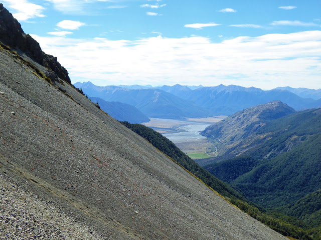
It's a nice enough 1 hour 40 minute (7km, 681m vertical gain) walk up a farm track to the summit. A beautiful autumn morning saw me shivering on the first bit but I soon warmed up as the elevation increased! For the first time in four visits, I met another person on the track, a hunter heading up on his quad bike (slightly jealous). Before long I was at the now familiar summit activation zone (the easement track runs through it) and got my requisite 4 contacts quickly on VHF (2m). As I was early, I tried UHF (70cm) and worked Ken ZL3OC in Timaru with strong signals. Jim ZL3ND popped up again so we worked on Fusion (C4FM), Jim using his handheld in the backyard. What was a scratchy FM contact became rock-solid audio when we switched to Fusion.

As my KX2 is still at the doctors, the little homebrew MTR3B (5 Watts CW-only) and trapped End Fed Half Wave (EFHW) were used. I usually rig this antenna as an Inverted V with the top of the pole close to the middle of the wire. I decided to try the inverted L configuration this time - theory being that getting the first section nearly vertical should improve low angle radiation on 20m - where the DX hangs out!

MTR3B, Tuner and tiny 450mAH LiPo

Trapped EFHW showing near-vertical first section. Track markers have many uses!

I worked the local ZLs on 40m with good signals. It was nice to work Philip ZL1PSH again from his Manukau Heads summit ZL1/AK-014. He's really getting the hang of this CW lark! Moved up to 30m and called CQ for 10 minutes - crickets... I was just about to switch to 20m and then John ZL3MR called me from Mount Barrosa ZL3/CB-499. Nice!

The antenna theory worked (or was it just a happy coincidence?) as, when I switched to 20m I had a nice pileup of VK stations and in amongst the pile, I heard "OH1". Responding "OH1?" I was thrilled to hear Pasi OH1MM calling me with a good signal in the clear. We exchanged reports and completed the contact, amazed that I was working Finland with 5W and a bit of wire -that's 17223 km!

As I was heading out the long way, I packed up HF about 11:30am and settled down to eat. With that the hunter I saw earlier came back down the track and stopped to chat. He asked the usual questions about what I was doing and seemed suitably impressed. Off he went down the steep, slippery track on his quad (I would rather be walking down...) and I had my lunch, listening to the stags roaring over in the Thirteen Mile Bush. Caught up with the locals on 2m after UTC rollover and was pleasantly surprised to get a call from John on 2m from Mount Barrosa. A bit scratchy but good enough - even with Mount Hutt right between us!


I headed down at 12:15pm local time with a big smile on my face - a very successful activation behind me and looking forward to the alternate descent route. 

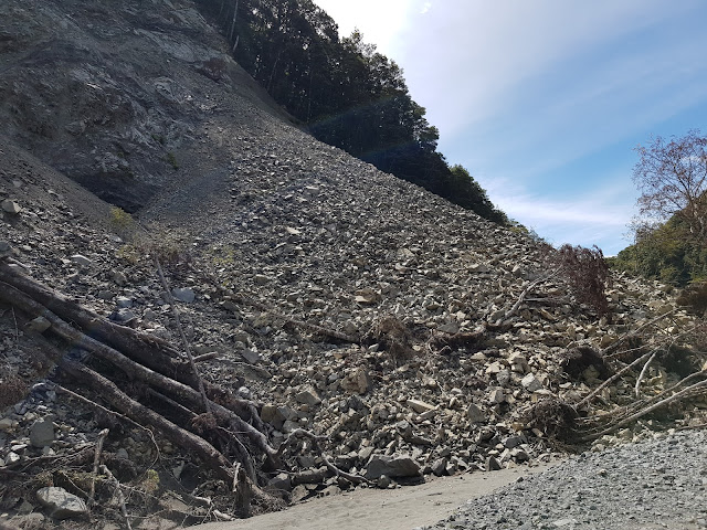
It was exactly as Mark described, a very nice walk through Beech forest down the spur to the Benmore Hut. Rough and lots of windfall in places to add to the challenge of staying on the track but OK. Still plenty of wasps about so be careful if off the track... 

Nice dappled-light section soon after entering the bush at the top

Once down at the Benmore Hut junction, you turn right and follow a well marked )and well pest-trapped) track back down to the Annavale Track junction and back out to the car. This section is pretty boggy in places and you cross a few streams, waterproof boots are a plus!

A much more interesting route than coming back down the farm track, this will be my default descent route for future activations of this very nice summit. It's an extra 2 km and 107m of climbing but well worth it. 2 hours 15 minutes from the summit to the car for me this way.

Thanks to all the Chasers and fellow Activators, local and DX - every call is appreciated!

Sunday, 27 March 2022

ZL3/CB-471 - un-named summit behind Woolshed Hill

Continuing our tour around the Craigieburn/Cass/Arthurs Pass area summits, Dave and I decided to tackle this un-named summit beyond Woolshed Hill, just across the river form Mt Horrible and Mt Bruce. Mark ZL3AB did the first activation of this hill in May 2021 so I will try not to duplicate the photos here.

Arriving at the start point of the Hawdon Shelter at 8am on a crisp autumn morning, we headed on up the first stretch which, as Mark pointed out, is a very quick gain in altitude indeed! Apart from the steepness, the thing that stands out is the massive predator trapping program going on, there are box traps every few metres right up to the Woolshed Hill summit and then PVC tunnel rodent/stoat bait stations beyond that right up to the base of our summit. Efficacy is born out by the abundant birdsong all the way up.

Emerging from the bush and getting on up the scrub, tussock and shingle sections you pass a nice wee tarn (pictured in Mark's blog) and then start climbing again to the Woolshed Hill summit. Extensive  patches of snow berries (Gaultheria depressa) provided a nice protein and vitamin C boost. This summit is a nice spot and is where most people stop however the SOTA peak is beyond so off we go, losing 100m of the hard earned height in the saddle before gaining it again up to the summit of  CB-471. A big bonus on this part of the climb was being checked out by a pair of young Kea. They circled high above us descending slowly until they were only about 15m above us. Fantastic sight.

The views are expansive across the Hawdon to the main divide, South West to the Craigieburn Range - everywhere! Here's the panoramic view.


We knew there was no line of sight to Christchurch for 2m so brought the 44' open wire fed doublet along (the open wire feed and the 2m Slim Jim don't play nicely together). This antenna is a firm favourite; tunes easily and efficiently on all bands 40-10m, is easy to erect and most importantly, produces lots of DX contacts.

Dave with the doublet on 6m pole. View up the Hawdon river

It soon proved itself again with Dave running a nice pileup on 40m SSB while I yelled into the ether on 2m... To my great surprise, Stuart ZL3ART called me with a good signal. being in Hillsborough, he is not elevated so a remarkable contact.

By now, Dave had run out of contacts so, after a nice S2S with Phillip ZL1PSH on Moir Hill, I hit the CW end of the band and worked our loyal gang of Chasers. Changing to 20m I was called by Chris F4WBN with a genuine 599 signal. We exchanged reports and completed the contact - 19,500km! Made my day. The higher bands produced plenty of VKs including an S2S with Peter VK3ZPF (author of VK Portalog) and a few JA contacts.

We decided to have lunch on the summit as there was very little breeze and terrific views

Nice lunch spot looking up the Hawdon River valley

Across the Waimakariri River to Mt Horrible (L) and Mt Bruce(R)


Heading down was uneventful - we ran into two couples heading up to Woolshed Hill and there was quite a crowd of vehicles back at the shelter - the Hawdon Hut was probably going to be fairly full!

Cell/4G coverage at the top was OK on Skinny/Spark and patchy on Vodafone.

Repeaters - None available

Time: 2.75 hrs up and 2.5 down

Permission: None needed - Arthurs Pass National Park (ZLFF-0002)

Access: Park/start at the Hawdon Shelter, across the Mt White Station bridge on SH73

Wednesday, 9 March 2022

Mt Bruce ZL3/CB-416 March 2022

 After three weekends off SOTA due to weather (1) and contests (2), I was keen to get out for a walk! The weather looked good so Dave ZL3DRN and I decided to head to Mt Bruce in the Craigieburn Forest Park Conservation Area ZLFF-0024 - just a bit further along than Mt Horrible which we did earlier in the year.

The morning dawned foggy which is always a good sign. We were keen to get an early start to get up before the heat of the day and a forecast Nor West change in the afternoon so left home at 6am, picked up Dave at Sheffield and arrived at the Cora Lynn Road DOC carpark just before 8am. There were plenty of cars there already but this is deceiving as it is the terminus of the Cass-Lagoon Saddle track. Dave assured me they wouldn't be heading for the summit and so it proved.

Heading off up the well marked track, the going is pretty easy until you emerge from the bush (manuka and beech) and strike off up the slope towards the ridge. We had 4 Kea above us at this point - a great sight. There's no track from here so it's a matter of tussock bashing your way up a fairly steep grade. Lots of micro-rests (to admire the view you understand...) were required on the way up but before too long, we arrived at the ridge and made our way along to the summit. Spectacular views abound. The weather was great with just a  light breeze. As we surveyed the horizon, big fluffy cumulus were already forming out towards the West and we resolved to keep an eye on them.

Nearly there...

There's no trig, just a pipe sticking out of the ground which was perfect to bungee the pole to. We were about an hour early (now there's a surprise!) so we took our time setting up the gear and had a look around. Mt Horrible looked quite insignificant from this altitude! We spotted a couple down in the saddle moving towards the summit and just as we started calling on 2m and HF, they arrived. Very fast, fit and carrying a hunting bow and substantial packs. We took a few moments to chat and they revealed that they had not had any luck hunting but were thoroughly enjoying the scenery and the walk.

I had modelled the VHF coverage using the excellent VE2DBE website and it had shown a very poor chance of any contacts back to Christchurch. However Mark ZL3AB was activating up near Hanmer so we set up the 5/8 wave Flowerpot on the mast to give it a try. I couldn't trigger any of the Canterbury repeaters but heard 147.05 about S3.


Looking West up the Bealey River towards Arthurs Pass.

Meanwhile Dave was plugging away on HF and got his 4 contacts on 60m and 40m including Warren ZL2AJ on Tuhua ZL1/MW-071. I worked Warren too and then hit the CW end of the band and picked up another S2S with Andrew VK1AD on Mt Coree VK1/AC-023. John VK4TJ and Andre ZL1TM rounded out my 4. A bit of a battle for a change! I moved to 20m and worked Peter VK3PF and Gerard VK2IO. With that, the first puff of Nor West hit us so we conferred and decided to pack up and head down off the summit into the top of the valley for lunch. Just as we switched off we got an alert that John ZL3MR was on a summit and calling. Switching the gear back on we found him with a good 40m signal from Mt Lyndon ZL3/CB-460. With John in our logs and no spots for/from Mark, we packed up and headed down the ridge to find a suitable scree for a rapid (and fun!) descent. 

Waimakariri River, SH73 snaking round Mt Horrible and some nice scree!

We moved down the stream from it's source until we found the start of the old Broad Stream track. It's still well marked with plenty of orange triangles but it is not shown on the current topo maps. It was a nice sheltered spot so we stopped and had a 30 minute lunch break with nice views right down the valley to Mt Horrible and Woolshed Hill.

Lunch - Mt Horrible slopes on the right, Woolshed Hill on the left

Track entrance, back into the Beech and out of the hot sun!

On with the packs and down the track. There are several sections where the track has been washed out or covered with slips so you need to keep your wits about you and search carefully for the next marker. Failing that, just following the stream down will do although there would be a lot of boulder hopping required.

There's an orange triangle under that lot...

At the bottom end of the valley you can either climb a bluff and follow triangles across to the carpark in the conservation area, cross the paddock (with prior permission from Cora Lynn Station Wilderness Lodge) or carry on down to the SH73 bridge and walk back along the highway and up Cora Lynn Road. Don't try a hybrid of the first two options like we did, I am still picking gorse spikes out of my hands...

Boulder hopping in the lower section

A big day and a very nice summit - highly recommend this one to fit activators.

Getting there: head on SH73 to Cora Lynn Road, go through the gate to the DOC carpark

Permission: None required however asking about crossing the paddock will make the end of the day easier!

Walking: 11.2 km circuit with 1100m of vertical gain

Times:  2 hours 40 min to the summit. About 3 hours for the exit via Broad Stream (inc. 30 mins for lunch).

2m coverage: Nil

Cell: patchy but 4G coverage on the summit VF and Spark/Skinny


Wednesday, 26 January 2022

ZL1/BP-132 Putauaki/Mt Edgecumbe January 2022

 Our annual trip to the Eastern Bay of Plenty to visit Francie's Dad saw me plotting another BoP summit. We usually get out fishing in the bay and I have often looked longingly at Putauaki as it is so distinctive. A quick Google and email to the Kawerau District Council i-Site led me to Maori Investments Limited who couldn't have been more helpful. Only requirement was a minimum of three in the party so a quick email to Warren ZL2AJ and that problem was solved! Warren ZL2JML, Ada ZL2ADA and Stephen ZL1HFT were lined up to join us, the permit was obtained and we were on! Finer details worked out via Messenger the week before and we all met at the Kawerau i-Site at 7:45am, climbed into Warren's Land Rover and off we went. The aim being to be on the summit before the heat of the day. Warren ZL2AJ has an impressive array of radios in his wagon - I don't think Ada was impressed when Warren ZL2JML admired the setup ;-)

We parked at the designated McKee road entry point for the South East track, AKA the "4WD track" (the NW track AKA the "Goat Track" is only open for the annual mountain race so sadly, a circuit was not on for us) and set off just after 8am. It's a fairly easy climb, just 600m of vertical gain over a 3.3km 4WD track and we made good time, arriving at the summit in 1 hour 20 minutes. Pleasing to see a lot of pest traps evident on the way, one of which had dispatched a very large wild cat. The trapping effectiveness was obvious with lots of native birdsong accompanying us up the mountain.

First glimpse of the summit - lots of towers...

With 5 operators, it could have been a challenge to get everyone set up but there was no drama. The VHF gear (Stephen ZL1HFT) obviously had to go on the trig and it was also the best spot to set up the dipoles for the two HF SSB stations. I headed back down off the summit to a disused concrete pad and set up my 40/30/20m trapped EFHW and MTR3B. There were 4 large towers with various comms and data links around us but the only interference we suffered was from the paging transmitters on 2m (oh, and some character on 20m CW interfering with the SSB stations... ;-)

The CW site and op(in orange) viewed from the trig site. Fire Watchtower in background


The 2m and HF SSB site set up under the trig.
L-R Stephen ZL1HFT, Ada ZL2ADA, Warren ZL2AJ , Warren ZL2JML

We were soon in business and I got called up the to summit to work Soren S2S on Pirongia on 2m and to my great surprise, Nick ZL1IU in the Bay of Islands, some 408km away! Great signals and checking with Nick later, tropospheric ducting was the likely mode. A doubling of my 2m distance record! Thanks Stephen ZL1HFT for doing the hard yards, hauling a TM-241A, halfwave antenna and a big battery up to the summit! I also had a local 70cm contact and a few nice S2S with the other ZL and VK activators - thanks all!

2m antenna g-clamped to the trig

We hit the mid-day propagation doldrums and it was getting quite hot so we decided to pack up and head down - looking forward to the shade of the bush once off the summit. A very pleasant descent and back to Warren's wagon - he soon whisked us back to Kawerau where we had a quick debrief, bid each other farewell and went our separate ways. It was a really nice activation, a good chance to chat with ops I normally only get to exchange signal reports with and get a new unique summit to boot.

This is a great summit to activate, I recommend it to all and will definitely do it again. Thanks to my co-activators, it was an enjoyable day.

Access: Contact Maori Investments Limited for a permit ($10), it's easy and quick: https://permits.maoriinvestments.co.nz/ They will issue the permit with a map and conditions of entry.

Time: They say to allow 2.5 hours, we did it in 1.5 hours - 600m of climbing over 3.3km of good 4WD track

2m coverage to Auckland, Waikato, BoP and Hawke's Bay (and Bay of Islands if you are lucky!). Plenty of space within the AZ to set up antennas.

Route from the forestry road - McKee Road


Tuesday, 18 January 2022

ZL3/CB-437 January 2022


This is an un-named, private summit which Dave ZL3DRN arranged access to and invited me along.

There is no track, route-finding required. A fairly simple bush-bash for a bit, a grunt up the spur to the ridge and a stroll around the tops, what could possibly go wrong?!

The day dawned cool with a forecast wind change and heat in the afternoon so we were up there at 7:30am to get the steep work done before the heat of the day. Parking the car at Craigieburn Cutting, we walked across the road and headed up through the beech forest - some animal trails evident and eventually we popped out on to a plateau of felled firs, many fire damaged. Picking our way through them took a while, it was pretty tough going as we couldn't find a clear path.

Arriving at the farm track, we picked the right hand side of the large gut and started up (middle of photo above). Steep and cluttered with debris, it was slow going and then we hit the shale/scree and hard clay... 

Yes, it really is that steep...

Eventually we arrived at the top of the spur and the first of three summits we would pass on the way to the SOTA peak at Pt 1578m. This one had a beaten up metal trig and a very old wooden one about 20m further on. The original surveyor must have been a bit out with his calculations!

From this point on it was ridge walking, great views and relatively easy. Lots of chamois sign and before too long we were rewarded with seeing a dozen of them just upwind of us. There's been no tourist hunting here for the past couple of years I guess so numbers are high. (As we arrived at the summit we disturbed a group of three does and their kids who then kindly posed so Dave could get a photo)

After passing the named summit, Broken Hill at 1486m, we were on the final climb up to our SOTA peak when an orange object appeared in front of us, a Stihl chainsaw left behind by one of the wilding pine contractors! We marked it's position on the GPS so we could find it on the return leg.

Not what you expect to find at 1420m!

After the hard slog, animal watching and chainsaw pondering, we arrived right on our alert time of 2200z/11am (3 hours 13 elapsed time, 2 hours 35 min moving time) and set about setting up the gear. I had made a poor HF antenna selection (doublet) given that we wanted to use the 2m vertical dipole (Flower Pot), of course the open wire feeders detuned the 2m antenna and our local chasers were stronger on the Handheld 1/4 whip! No harm done and we worked S2S with John ZL3MR when he arrived at Mt Hutt. HF went OK with our loyal ZL and VK Chasers and JA5QJX/0 worked. S2S with Ian ZL3GIG (Trig M), Warren ZL2AJ (Maungatautari) and Simon ZL1THH (ZL1/WK-192 ).

Spot the obvious issue...

The forecast wind change arrived so we pulled down the HF antenna and put the pole back up to confirm my theory about the detuning of 2m. Had lunch and then worked the locals after rollover on 2m - booming in!! A quick pack-up and we set off.

Arriving back at the chainsaw, we decided not to carry it down (due to the steep final descent down the spur) and that we would simply send the owner the waypoint location. Dave couldn't resist starting it (5 pulls) and we made a short video for Chris ZL4RA's benefit, showing how WE deal with wilding pine in CB! 


The descent down the spur was uneventful - Dave found us some scree to use and it was much faster than when we climbed it! From our vantage point, we picked out the path through the felled firs and headed for that - much easier going this time and we were soon back into the beech forest. Dave had warned me about the wasps before we set out... About 3/4 of the way down, I hear all this swearing behind me (not his usual trait), I turn around and here's Dave surrounded by angry wasps... I had stood on the nest and they came out angry and attacked him behind me...We hustled down the last bit and he hit the welcome stream at the bottom and got rid of the last of them. Back across the road to the car and a couple of  anti-histamine tablets into him.

The obligatory stop was made at the Yello Shack in Springfield where the owner now recognises us and off home. A great day with the only downside being the wasp attack. Another summit I probably won't return to but one I am glad we did.


Access details - Private summit, please check with Dave ZL3DRN

Time: 3 1/4 hours to the top (2 hours 35 moving time)

Cell: Vodafone good, Spark/Skinny patchy

Repeaters: not tried but good 2m coverage to Christchurch

Sunday, 9 January 2022

Mt Horrible ZL3/CB-545 January 2022

 I'd selected this summit for my New Years day activation and gave up after the first 100m (vertical) Straight up from the SH73 (50% grade) and plenty of chest high regenerating scrub to bash through. 

A week later Dave ZL3DRN was back from holiday and keen to get out - let's plan a better route up Mt Horrible and get it done! Plotting my previous attempt on topomap and Google Earth showed that I had taken the wrong option when faced with the wall of scrub. Turning around was the right option. New route planned and loaded to the GPS and we were off. 

Arriving at the layby at 8:30am, Dave looked up and commented "are you sure this is the best access?!" We set off and using the new route, picked and bashed our way up. The first 300m of climbing is very steep and punctuated by walls of pig fern, vicious wild rose hip and matagouri. Several sections required some rock climbing on crumbly, flakey rock - more on this later...

View looking straight up from the carpark...

Once we emerged from the scrub, we picked up an old track which went all the way to the summit, along the very route we had planned. It was good travelling, up the spur and along the ridge to the summit. There used to be a track to the summit from just West of Paddy's Bend (but not since the big fires). 

We arrived at the summit 2 hours after leaving the car. 


The views are magnificent in all directions, so here's the obligatory panorama!


Antenna (EFHW), pole and 2m antenna with the Hawdon River and ZL3/CB-471 Woolshed Hill in the background

We were early but keen to get set up to ensure we got Mark ZL3AB on Mt Southey. I was trying a new 5/8 wave portable roll-up antenna for 2m, the Flower Pot designed by VK2ZOI. The choke slips over the telescoping mast and the top sits up at about 5m. We worked Ross ZL3RJ in Rangiora and Rick ZL3RIK in Hornby with good signals. On to HF and used the 60m EFHW to work the CHC Chasers who couldn't hear us on 2m including John ZL3MR on ZL3/CB-822 Mt Pleasant. 60m proves it's worth again. Taking out the 60m coil, 40m was in good shape and we worked S2S with Warren ZL2JML and Ada ZL2ADA on ZL1/WK-024, Don ZL3DMC on ZL3/CB-760 Pearce, Richard ZL4FZ on ZL3/SL-307 Bluff Hill and Mark ZL3AB on ZL3/CB-383 Mt Southey, a very pleasing haul of S2S points! We worked our way up the bands and our usual loyal ZL and VK Chasers and JH1MXV (on 15m). Nothing worked on 10m this time.

We had decided we would follow the track back down past where we joined it to see if we could find a better starting point and so packed up HF at 12.30pm and had lunch, worked Don and Rick again on 2m after rollover and headed straight back down the hill.

The descent plan was looking good for a while but then the track petered out as we got to the area that had been burnt and regenerated with very thick fern walls and no clear way down. The decision was made to turn around and go back down the way we had ascended. Unfortunately this meant re-climbing another 200m vertical... We were following the backtrack of our ascent but it was still tough to find a way through. Dave took the fast way at one stage - unintentionally. A victim of the crumbly rock and wild rose hip, he managed to flip over and arrest his slide after about 6m, it was scary to watch...


We got back to the car about 4pm, tired but exhilarated after activating a new one!

Be careful if you attempt this summit, the summit itself is very pleasant with great views. It's very dangerous coming down the last 100 vertical metres, if you do decide to tackle it, please take someone else with you.

Directions: Drive on SH73 to just West of Paddy's bend, there is a layby (-43.027741 171.688414). Park there and head straight up!

Time: 2 hours, 3.5km and 689m vertical with some scrub-bashing

Repeaters: 705 accessible. 2m Simplex OK to certain CHC areas

Cell: Spark and Vodafone 4G thanks to the celltower near the Mt White bridge. Skinny not good

Permission: Not required, Mt Horrible Conservation Area


Sunday, 7 November 2021

Big Ben Range ZL3/CB-857 6th November 2021

 This is an un-named summit in the Korowai/Torlesse Tussocklands Park. It's the peak NE of Ben More and 5m higher, hence why we were headed there! We had a false start a few weeks ago when a dump of rain on the Friday meant that it was too icy to attempt. No problems this time and, with an improving forecast, we headed up to Lake Lyndon for a nice early start. DOC has closed vehicle access to the area so it was a case of parking on the Lyndon road 1km past the Lyndon Lodge turnoff (near the "Z" bend).

Dave ZL3DRN did the first activation of this summit so we used his GPX route up a very steep (51% grade) initial climb to attain the ridge. After that it's  a much easier route up the ridge to the summit. All the while looking south at the route he had planned for our descent - more on that later...

We made good time up to the summit - my climbing fitness is certainly improving, arriving about 1.5 hours before our alerted time... Regular readers will notice a pattern here. As forecast, the Canterbury Plains were blanketed in thick cloud but we had spectacular views of the mountains around us.

Christchurch is out there somewhere! Nice up here at 1660m ASL though.

We used the Repeater hut as shelter from the very light breeze and set up the gear - antenna du jour is the 40m EFHW with switchable 60m loading coil designed by Stephan HB9EAJ. I really like this antenna for it's ease of setup, End Fed convenience and it's fairly light weight. Oh, and it's resonant on 7 bands!

Dave in action with the KX2. 6m pole in the background, EFHW matching unit bungeed to my pack

John ZL3MR was on Mt Barrosa ZL3/CB-499 and had also arrived early. Even though Mt Hutt was directly in the way, we managed 2m S2S contacts with him. The Christchurch gang were quickly worked on 2m also and then we hit the HF bands. We weren't expecting much given the Geomagnetic storm but it worked out OK with nice S2S contacts with Andrew VK1AD/2 and Matt ZL3NVW. Also worked were VK1MA, VK1MCW, VK5PAS, VK5IS and JA5QJX/0 plus our loyal ZLs on 40m and 60m.

Our summit peace and quiet had been invaded by a large, noisy tramping club group so we packed up and headed across the saddle to Ben More for lunch. (Unfortunately so did the other group!). It's a nice summit too with the remains of a trig and great views.
Dave in his happy place. Lunch at Ben More with the ridge we ascended in the foreground.                   L to R ZL3/CB-570, Mt Lyndon CB-460 and Trig M CB-536 behind with just a glimpse of the SE end of Lake Lyndon

The rest of the route home was great, walking along the tops with spectacular views either side, what's not to like?!
Route home is via the long ridge to the left of shot. The ridge we ascended is the scrubby one on the right. Lake Coleridge in the background with Peak Hill CB-542 in the background.

Google Earth view of our route. Lake Lyndon in the background.

Apart from a fairly steep scramble down the last spur (36%) and a real bash/crawl through some Matagouri (in flower so at least it smelled nice!) after crossing the Acheron River, we made good time down and back to the vehicle. A quick stop at Lake Lyndon for a fish (unrewarded) on the way out and we were off home after another epic day. Thanks Dave for pushing me to extend my limits.

Summary:
15.8 km walked
1307 vertical metres
4 Hours 51 min walking time

Getting there: Head over Porters Pass on State highway 73 before turning left at Lake Lyndon and driving about 5 kilometres. Just before the road turns hard right (Z corner) right there is an area you can park. Note that vehicle access is not permitted into the park itself now. 

Permission: None needed - Korowai/Torlesse Tussocklands Park

Trig: None, repeater station on the summit

Cell Coverage: None until at the summit. Spark better than Vodafone but still very patchy.

Repeaters: 705 and 2m simplex to Christchurch is easy - direct line of sight.

Time to the top: Allow 3 to 3.5 hours up. It is a 6.3km walk up with 941m of climbing.


Update: Thanks to Dave for the photo of me in the Matagouri, it was pretty tough going!